This article describes a recent observation of a tornado that passed close to Fort Collins, CO on May 22, 2008.
Introduction
A tornadic supercell thunderstorm moved across parts of Weld and Larimer counties around mid-day local time on May 22, 2008. The town of Windsor, Colorado experienced extensive damage. On this date, the CSU-CHILL radar's antenna control system was being adapted to the new dual offset feed antenna, so routine data collection operations were not possible. Once National Weather Service tornado warnings were issued, however, the radar was brought up with limited antenna motion capability. These efforts were hampered by commercial power fluctuations that were probably related to easterly surface winds that were gusting above 40 knots at the Greeley Airport.
Radar Data and Ground Observations
CSU-CHILL data collection began shortly after the northwest-bound storm had crossed I-25 north of Ft. Collins. A survey of the region west of I-25 and north of Ft. Collins revealed spotty damage along the storm track. (This area was just beyond the end of storm's overall tornadic damage path as identified in a post-event survey conducted by the Boulder NWS office.) Damage observations are marked as placemarks on the Google Maps presentation shown below. The most significant damage (a flipped car and RV; removed roof sections, etc.) was found at the two northwestern-most landmarks.
Tornado Track and Damage Reports
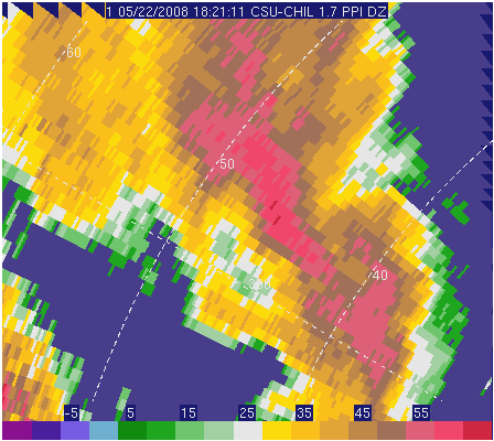
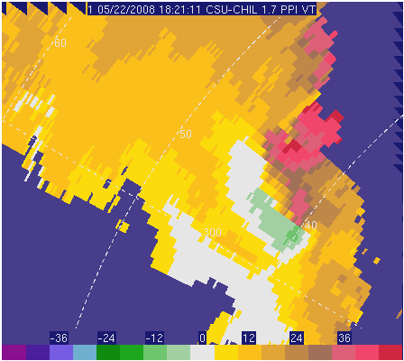
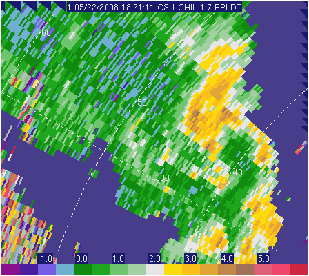
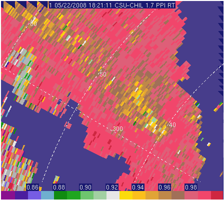
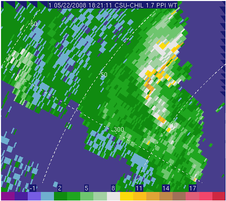
The figure below is an interactive presentation of the radar observations. Clicking on the placemarks ( ) expands them, showing observed damage on the ground. The 1.4° elevation angle PPI scan data was collected at 1830 UTC when the radial velocity rotation signature was nearest to the primary ground damage location. The red line indicates the approximate path of the tornado, according to the NOAA damage report.
Loading map...
{"minzoom":false,"maxzoom":false,"mappingservice":"leaflet","width":"auto","height":"600px","centre":false,"title":"","label":"","icon":"","lines":[{"text":"\u003Cb\u003E\u003Cdiv class=\"mw-content-ltr mw-parser-output\" lang=\"en\" dir=\"ltr\"\u003E\u003Cp\u003EGround Track\n\u003C/p\u003E\u003C/div\u003E\u003C/b\u003E\u003Cdiv class=\"mw-content-ltr mw-parser-output\" lang=\"en\" dir=\"ltr\"\u003E\u003Cp\u003ETornado Ground Track\n\u003C/p\u003E\u003C/div\u003E","title":"Ground Track\n","link":"","strokeColor":"red","strokeOpacity":"0.75","strokeWeight":"5","pos":[{"lat":40.262499,"lon":-104.771118},{"lat":40.280311,"lon":-104.798241},{"lat":40.330057,"lon":-104.810257},{"lat":40.377936,"lon":-104.836349},{"lat":40.438325,"lon":-104.869995},{"lat":40.485865,"lon":-104.889908},{"lat":40.55007,"lon":-104.942093},{"lat":40.591014,"lon":-104.952049},{"lat":40.64027,"lon":-104.985008},{"lat":40.667879,"lon":-105.006638},{"lat":40.6822,"lon":-105.020027}]},{"text":"","title":"","link":"","strokeColor":"#FF0000","strokeOpacity":"1","strokeWeight":"2","pos":[]}],"polygons":[],"circles":[],"rectangles":[],"copycoords":false,"static":false,"zoom":false,"defzoom":14,"layers":["OpenTopoMap","OpenStreetMap"],"image layers":[],"overlays":[],"resizable":false,"fullscreen":false,"scrollwheelzoom":false,"cluster":false,"clustermaxzoom":20,"clusterzoomonclick":true,"clustermaxradius":80,"clusterspiderfy":true,"geojson":"","clicktarget":"","imageLayers":[],"locations":[{"text":"\u003Cb\u003E\u003Cdiv class=\"mw-content-ltr mw-parser-output\" lang=\"en\" dir=\"ltr\"\u003E\u003Cp\u003E\u003Cb\u003EIrrigation Pivot\u003C/b\u003E\n\u003C/p\u003E\u003C/div\u003E\u003C/b\u003E\u003Cdiv class=\"mw-content-ltr mw-parser-output\" lang=\"en\" dir=\"ltr\"\u003E\u003Cp\u003E\u003Cspan typeof=\"mw:File\"\u003E\u003Ca href=\"/w/File:Pivot_damage.jpg\" class=\"mw-file-description\"\u003E\u003Cimg src=\"/images/thumb/a/a4/Pivot_damage.jpg/150px-Pivot_damage.jpg\" decoding=\"async\" width=\"150\" height=\"113\" class=\"mw-file-element\" srcset=\"/images/thumb/a/a4/Pivot_damage.jpg/225px-Pivot_damage.jpg 1.5x, /images/thumb/a/a4/Pivot_damage.jpg/300px-Pivot_damage.jpg 2x\" /\u003E\u003C/a\u003E\u003C/span\u003E\u003Cbr /\u003EOnly isolated damage like this disrupted irrigation pivot, was found immediately west of I-25. \u003Cb\u003E\u003Ca class=\"mw-selflink-fragment\" href=\"#Irrigation_Pivot\"\u003E(more)\u003C/a\u003E\u003C/b\u003E\n\u003C/p\u003E\u003C/div\u003E","title":"Irrigation Pivot\n","link":"","lat":40.66473,"lon":-105.01583,"icon":""},{"text":"\u003Cdiv class=\"mw-content-ltr mw-parser-output\" lang=\"en\" dir=\"ltr\"\u003E\u003Cp\u003EAn outbuilding was tipped over at this location. (Photograph not currently available.)\n\u003C/p\u003E\u003C/div\u003E","title":"An outbuilding was tipped over at this location. (Photograph not currently available.)\n","link":"","lat":40.68169,"lon":-105.07159,"icon":""},{"text":"\u003Cb\u003E\u003Cdiv class=\"mw-content-ltr mw-parser-output\" lang=\"en\" dir=\"ltr\"\u003E\u003Cp\u003E\u003Cb\u003EHouse\u003C/b\u003E\n\u003C/p\u003E\u003C/div\u003E\u003C/b\u003E\u003Cdiv class=\"mw-content-ltr mw-parser-output\" lang=\"en\" dir=\"ltr\"\u003E\u003Cp\u003E\u003Cspan typeof=\"mw:File\"\u003E\u003Ca href=\"/w/File:Parked_car_damage.jpg\" class=\"mw-file-description\"\u003E\u003Cimg src=\"/images/thumb/d/d0/Parked_car_damage.jpg/150px-Parked_car_damage.jpg\" decoding=\"async\" width=\"150\" height=\"113\" class=\"mw-file-element\" srcset=\"/images/thumb/d/d0/Parked_car_damage.jpg/225px-Parked_car_damage.jpg 1.5x, /images/thumb/d/d0/Parked_car_damage.jpg/300px-Parked_car_damage.jpg 2x\" /\u003E\u003C/a\u003E\u003C/span\u003E \u003Cbr /\u003EThis parked car was swept around the corner of a house and rolled over. \u003Cb\u003E\u003Ca class=\"mw-selflink-fragment\" href=\"#Overturned_Car\"\u003E(more)\u003C/a\u003E\u003C/b\u003E\n\u003C/p\u003E\u003C/div\u003E","title":"House\n","link":"","lat":40.71173,"lon":-105.09533,"icon":""},{"text":"\u003Cb\u003E\u003Cdiv class=\"mw-content-ltr mw-parser-output\" lang=\"en\" dir=\"ltr\"\u003E\u003Cp\u003E\u003Cb\u003EBarn\u003C/b\u003E\n\u003C/p\u003E\u003C/div\u003E\u003C/b\u003E\u003Cdiv class=\"mw-content-ltr mw-parser-output\" lang=\"en\" dir=\"ltr\"\u003E\u003Cp\u003E\u003Cspan typeof=\"mw:File\"\u003E\u003Ca href=\"/w/File:Roof_damage.jpg\" class=\"mw-file-description\"\u003E\u003Cimg src=\"/images/thumb/e/e8/Roof_damage.jpg/150px-Roof_damage.jpg\" decoding=\"async\" width=\"150\" height=\"113\" class=\"mw-file-element\" srcset=\"/images/thumb/e/e8/Roof_damage.jpg/225px-Roof_damage.jpg 1.5x, /images/thumb/e/e8/Roof_damage.jpg/300px-Roof_damage.jpg 2x\" /\u003E\u003C/a\u003E\u003C/span\u003E \u003Cbr /\u003EPortions of this well-constructed barn roof were removed. \u003Cb\u003E\u003Ca class=\"mw-selflink-fragment\" href=\"#Roof_Damage\"\u003E(more)\u003C/a\u003E\u003C/b\u003E\n\u003C/p\u003E\u003C/div\u003E","title":"Barn\n","link":"","lat":40.71812,"lon":-105.09726,"icon":""},{"text":"\u003Cb\u003E\u003Cdiv class=\"mw-content-ltr mw-parser-output\" lang=\"en\" dir=\"ltr\"\u003E\u003Cp\u003E\u003Ca href=\"/w/CSU-CHILL_main_site\" title=\"CSU-CHILL main site\"\u003ECSU-CHILL main site\u003C/a\u003E\n\u003C/p\u003E\u003C/div\u003E\u003C/b\u003E\u003Cdiv class=\"mw-content-ltr mw-parser-output\" lang=\"en\" dir=\"ltr\"\u003E\u003Cp\u003EThe main CSU-CHILL radar site \u003Cspan typeof=\"mw:File\"\u003E\u003Ca href=\"/w/File:CHILL_Radome.jpg\" class=\"mw-file-description\"\u003E\u003Cimg src=\"/images/thumb/0/0b/CHILL_Radome.jpg/100px-CHILL_Radome.jpg\" decoding=\"async\" width=\"100\" height=\"67\" class=\"mw-file-element\" srcset=\"/images/thumb/0/0b/CHILL_Radome.jpg/150px-CHILL_Radome.jpg 1.5x, /images/thumb/0/0b/CHILL_Radome.jpg/200px-CHILL_Radome.jpg 2x\" /\u003E\u003C/a\u003E\u003C/span\u003E\n\u003C/p\u003E\u003C/div\u003E","title":"CSU-CHILL main site\n","link":"","lat":40.44625,"lon":-104.63708,"icon":""}],"imageoverlays":null}
Polarimetric observations
Some interesting radar data values are found in the rotation area: On the inbound side,  values are significantly more positive than the near 0 dB differential reflectivity levels typically found in hail. For example, a near 0 dB / high reflectivity hail signature is present in the southern part of the echo system over northern Ft. Collins. The co-polar H,V correlation (
 ) values in the southwestern half of the circulation are slightly reduced from the typical "pure rain" levels (> ~0.98). Prior research [1] has associated significant reductions (sometimes less than 0.5) in the immediate vicinity of tornadoes with echo returns from lofted debris. The reductions seen here are not particularly large, but only remnants of the tornado existed at 1830 UTC. One region of high radial velocity spectral widths was essentially co-located with the flipped car landmark. This high spectral width patch may have been related to sub-pulse volume scale circulations.
Note: The radar was operating in simultaneous VHS (simultaneous transmit) mode during the time period shown here. The moment fields were calculated in post-processing from archived time series data; no clutter filtering was applied.
These results are preliminary; additional, more extensive data analysis are anticipated in the future.
Time-lapse
Reflectivity
|
Click play to begin animation |
|
|
|
|
Velocity
|
Click play to begin animation |
|
|
|
|
Differential Reflectivity
|
Click play to begin animation |
|
|
|
|
Correlation Coefficient
|
Click play to begin animation |
|
|
|
|
Spectrum Width
|
Click play to begin animation |
|
|
|
|
Ground Damage
Irrigation Pivot
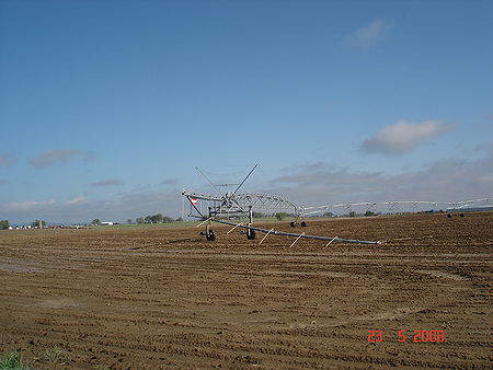
Only isolated damage like this disrupted irrigation pivot, was found immediately west of I-25. Picture courtesy Miguel Galvez.
Overturned Car
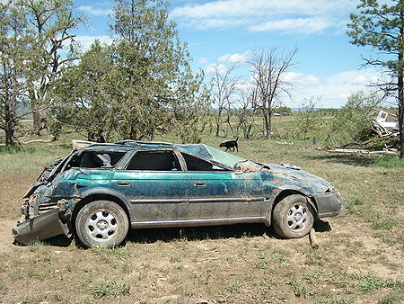
This parked car was swept around the corner of a house and rolled over. Picture courtesy Pat Kennedy.
Roof Damage
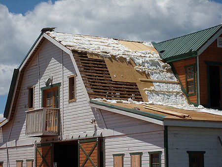
Portions of this well-constructed barn roof were removed. Picture courtesy Pat Kennedy.
External References and Links
References
- ↑ Ryzhkov et al, Bulletin of the American Meteorological Society, (June, 2005)
Links


