Casebook 20 May 2004
CSU-CHILL Casebook: 20 May, 2004
During the early evening hours of 20 May, 2004 (21 May on UTC), an isolated thunderstorm developed approximately 35 km south-southwest of the CSU-CHILL radar. This storm rapidly intensified; 1.5 inch diameter hail was reported at 0031 UTC. As the storm moved eastward into Morgan County, a weak echo region (WER) was evident in association with main updraft. (The locally encircled reflectivity minimum visible on PPI sweep 2 (azmiuth 101 degrees / range 76 km) was surmounted by a high reflectivity area on sweep 7. See the first two VCHILL example images below.) A thunderstorm RHI scan through the WER at 0230 UTC is shown in the third VCHILL example image. (Note: severe weather spotters reported a tornado 1 mile northwest of the city of Fort Morgan at 0229 UTC.)
-
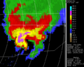
Reflectivity PPI
-
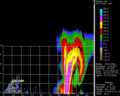
Reflectivity RHI through thunderstorm

