High rain rates at Denver International Airport on 23 June 2009
Introduction
Very heavy rain and hail up to .75 inches in diameter were observed at the Denver
International Airport (KDEN) around 2200 UTC (1600 MDT) on 23 June 2009. The CSU-CHILL radar (located near Greeley, CO) collected data from this precipitation area via a series of low elevation angle PPI scans that were done in alternating VH transmit polarization mode.
All of the plots shown below came from a 0.5 degree sweep that passed over the airport
at 2209 UTC. The basic CHILL polar coordinate data were processed with the
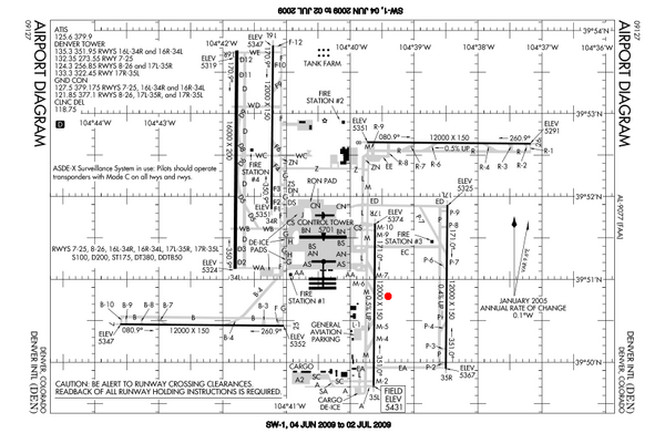
DROPS (Dualpol Radar Operational Product System) software developed in the Radar Laboratory group at the CSU Electrical and Computer Engineering Department. This software removes non-precipitation echoes, calculates specific differential propagation phase (Kdp), and outputs an instantaneous rain rate value at each gate based on an objectively-selected rate estimator (i.e., R(Z,Zdr); R(Kdp), etc.). (An outline of the original version of this blended rain estimation scheme can be found in Cifelli et al., JGR 2002). The NCAR SPRINT program was used interpolate the DROPS output to a 0.5 km X, Y Cartesian grid on the constant elevation PPI surface. To provide a geographic reference, contour plots of the gridded radar data fields were superimposed on a diagram of the airport taxiway and runway system. The basic airport diagram chart is shown below. The red dot indicates the approximate location of the ASOS automated surface weather sensing equipment.

Reflectivity ()
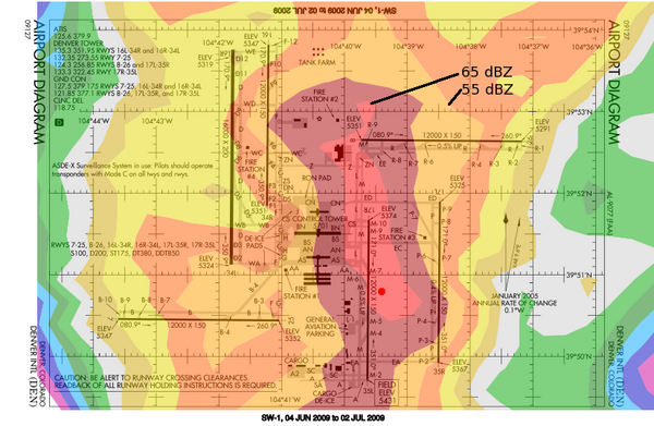
Reflectivity levels exceeded 60 dBZ over much of the eastern portion of the
airport. The runway 35L visual range values dropped to 2200 feet in the 2208
METAR report. The storm's passage caused an approximately one hour-long suspension
of flight operations.

Specific Differential Phase (Kdp; deg / km)
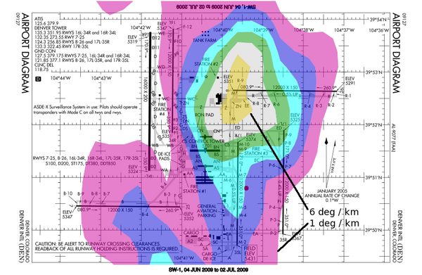
The high concentrations of large, oblate rain drops generated appreciable positive
Kdp magnitudes over most of the airport. Peak values exceeded 6 deg / km in
the northeast quadrant of the runway complex.

Rain rate (mm / hr)
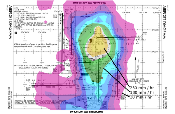
Instantaneous rain rates greater than 200 mm /hr were diagnosed. The existence
of intense rain rates was verified by the METAR report remarks. The ASOS
gauge located near the mid-point of runway 35L recorded 1.12 inches of
rain between 2208 and 2220 UTC. (An average rate of 122 mm / hr).

Acknowledgements
Mr. Chuck Cannon of the Denver International Airport staff provided a personal account of the storm's impacts at the airport.
