DPWX/Dual polarization hail signatures observed by the CSU-CHILL and NWS KCYS radars: 23 June 2014
Author: P. C. Kennedy
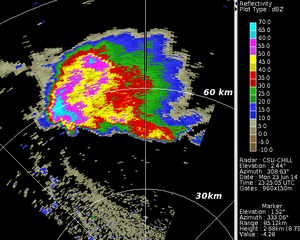
CSU-CHILL reflectivity data collected in a low elevation angle PPI scan through a hailstorm on 23 June 2014. Selected dual polarization data plots from this storm have been prepared using an RHI scan from the CSU-CHILL radar and a surveilance scan from the NWS KCYS radar.
Overview
Hailstones, especially those with diameters above ~1.9 cm (.75 inches), undergo large, nearly random fluctuations in orientation as they fall. Their shapes are also typically quasi-spherical. These characteristics cause their backscattering cross sections to be nearly equal with respect to the horizontally and vertically polarized illumination provided by a dual polarization weather radar. In contrast, the balance of the aerodynamic and surface tension forces acting on falling raindrops tends to deform them into oblate (flattened) spheriods. Thus, raindrops (especially for diameters larger than 1 mm) consistently present a backscattering cross section that is larger for H waves than for V waves. This preferred orientation causes the horizontally polarized return signal received from raindrops to be stronger than the vertically polarized received signal. In contrast, the H and V signals levels returned by hailstones will be more nearly equal. These effects are seen in differential reflectivity () field output by dual polarization radars. is the ratio of the H to V return signal levels expressed on a logarithmic scale. Under this definition, the quasi-equal H and V received signal levels produced by hail will give values near 0 dB, while oblate raindrops will produce values in the general +0.75 to +4 dB range. These variations are among the dual polarization signatures that were observed by the CSU-CHILL and NWS KCYS radars on 23 June 2014.
CSU-CHILL RHI data
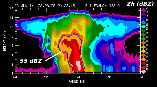
The following data plots were made from an RHI scan conducted by the CSU-CHILL radar at 2323 UTC through the reflectivity core of a hailstorm on 23 June 2014. maximum reflectivity levels exceeded 70 dBZ in a small area near the 60 km range point. The overhanging reflectivity configuration on the near range side of the storm and the domed echo summit indicate that a strong updraft was present. For reference, the 55 dBZ reflectivity contour is included in all of the RHI plots.
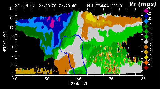
The corresponding radial velocity pattern contains surface convergence at the near range edge of the reflectivity core, and divergence centered on the echo summit is evident at the anvil level. The vertical alignment of these two features suggests that they are connected by a well defined updraft. The smooth radial velocity patterns are disrupted at heights below ~8 km AGL and ranges beyond the reflectivity core. This disruption is a consequence of the three body scattering interactions that were taking place between the highly reflective scatterers in the echo core aloft and the underlying ground surface [Wilson and Reum 1988].
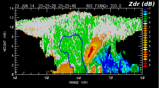
The next plot shows the corresponding field. values of 0 dB and lower are found at the surface in the echo core region where a significant concentration of hailstones exists. Slightly negative S-band values have been previously reported in areas of moderate to large diameter hailstones [Zrnic et al. 1993]. In agreement with [Hubbert and Bringi 2000], the three body scattering region is marked by distinctly positive values at higher elevation angles and negative values at near surface elevations.
KCYS PPI data
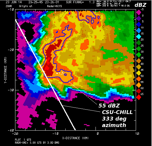
The NWS radar in Cheyenne Wyoming (KCYS) was collecting data from this same storm at relatively short range (~40 km). Data from the KCYS 1.3 degree elevation angle scan taken at ~2325 UTC is shown below. As outlined by the 55 dBZ reflectivity contour, the low level reflectivity core assumed an 'L" shaped configuration at this time. Due to three body scattering down range from KCYS, a lower reflectivity appendage extended southwestward from the echo core.
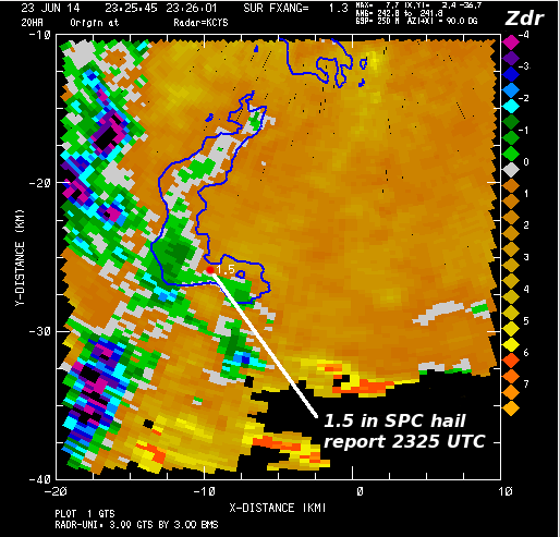
The corresponding KCYS field is shown below. The presence of hail has reduced the to or below 0 dB in much of the echo core. The existence of hail was confirmed by an SPC report of 1.5 inch diameter hail at 2325 UTC. As was the case in the CHILL RHI data, negative values were prevelant in the three body scattering region at this low elevation angle.
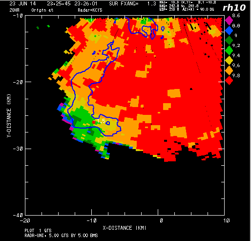
In addition to near 0 dB values, hailstones can reduce the correlation between the co-polar H and V received signals (). This reduction is increased when the hailstones have significant shape irregularities and when they are mixed with rain, producing a wide variety of particle shapes and diameters within the radar pulse volume. In the following plot, spatially smoothed KCYS values have been multiplied by 10. Correlation reductions to ~0.92 occurred in the vicinity of the hail report. To the east of the hail area more modest reflectivities and positive values prevailed in the rain area. In this essentially hail-free, pure rain regime, the correlation values exceeded 0.98
Conclusions
Consistent dual polarization indications of hail were obtained by the CSU-CHILL research and operational NWS KCYS radars on 23 June 2014.
References
- [*Wilson and Reum 1988] Wilson, James W., Darelyn Reum, 1988: The Flare Echo: Reflectivity and Velocity Signature. J. Atmos. Oceanic Technol., 5, 197–205.
- [*Zrnic et al. 1993] Zrnic, D. S., V. N. Bringi, N. Balakrishnan, K. Aydin, V. Chandrasekar, J. Hubbert, 1993: Polarimetric Measurements in a Severe Hailstorm. Mon. Wea. Rev., 121, 2223–2238.
- [*Hubbert and Bringi 2000] Hubbert, J. C., V. N. Bringi, 2000: The Effects of Three-Body Scattering on Differential Reflectivity Signatures. J. Atmos. Oceanic Technol., 17, 51–61.

