DPWX/Zdr regimes in echoes from insects and raindrops: 1 July 2015: Difference between revisions
Pat kennedy (talk | contribs) (Initial image posting) |
Pat kennedy (talk | contribs) (Initial text entry.) |
||
| Line 1: | Line 1: | ||
==Overview== | |||
During the afternoon hours of 1 July 2015 the CSU-CHILL radar conducted continuous 360 degree surveillance scans at a single elevation angle (1.9 degrees). This scan pattern provided high time resolution (~1 minute and 30 seconds) updates on the evolution of the low level echo field. During the observation period, rain shafts from developing thunderstorms penetrated downwards into the insect-laden boundary layer. | |||
==Reflectivity loop== | ==Reflectivity loop== | ||
In the following reflectivity sequence the widespread, horizontally uneven coverage of modest reflectivity (~10 - 20 dBZ) echoes is typically of a convectively-active warm season boundary layer. These non-precipitating clear air echoes are carried westward with the low level synoptic wind field. As time progresses, isolated higher reflectivity rain echoes appear from thunderstorms that are developing at higher levels. The westerly winds at these higher levels cause the rain echoes to move opposite to the boundary layer echo motion. | |||
<center> | <center> | ||
<imgloop delay=200 imgprefix="http://www.chill.colostate.edu/anim/apr_2016_01jul2015_zdr/" width=640 height=512> | <imgloop delay=200 imgprefix="http://www.chill.colostate.edu/anim/apr_2016_01jul2015_zdr/" width=640 height=512> | ||
| Line 48: | Line 54: | ||
==Zdr loop== | ==Zdr loop== | ||
The next loop shows the differential reflectivity (Zdr) data from the same sequence of images. The clear air echoes are characterized by highly positive (~ +6 dB) Zdr values. These magnitudes are typical of the highly oblate shapes that are typical of insects. The mean shapes of the raindrops in the developing precipitation shafts are less flattened than the typical insect bodies; resulting in lower magnitude Zdr values (~ +2 dB). Brief episodes of higher Zdr levels appear during episodes the higher reflectivity in the rain showers when larger diameter drops are present. | |||
==Reflectivity loop== | ==Reflectivity loop== | ||
<center> | <center> | ||
Revision as of 05:15, 22 April 2016
Overview
During the afternoon hours of 1 July 2015 the CSU-CHILL radar conducted continuous 360 degree surveillance scans at a single elevation angle (1.9 degrees). This scan pattern provided high time resolution (~1 minute and 30 seconds) updates on the evolution of the low level echo field. During the observation period, rain shafts from developing thunderstorms penetrated downwards into the insect-laden boundary layer.
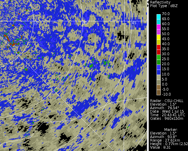
Reflectivity loop
In the following reflectivity sequence the widespread, horizontally uneven coverage of modest reflectivity (~10 - 20 dBZ) echoes is typically of a convectively-active warm season boundary layer. These non-precipitating clear air echoes are carried westward with the low level synoptic wind field. As time progresses, isolated higher reflectivity rain echoes appear from thunderstorms that are developing at higher levels. The westerly winds at these higher levels cause the rain echoes to move opposite to the boundary layer echo motion.
|
|
||
|
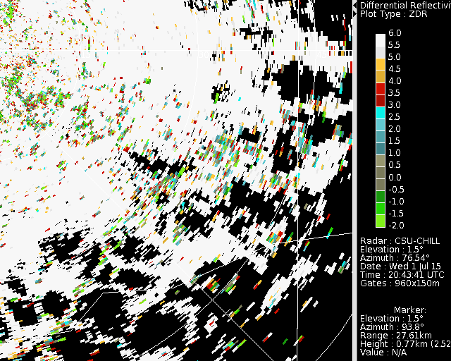
Zdr loop
The next loop shows the differential reflectivity (Zdr) data from the same sequence of images. The clear air echoes are characterized by highly positive (~ +6 dB) Zdr values. These magnitudes are typical of the highly oblate shapes that are typical of insects. The mean shapes of the raindrops in the developing precipitation shafts are less flattened than the typical insect bodies; resulting in lower magnitude Zdr values (~ +2 dB). Brief episodes of higher Zdr levels appear during episodes the higher reflectivity in the rain showers when larger diameter drops are present.
Reflectivity loop
|
|
||
|
KFTG data

