DPWX/Zdr and phidp variations in a developing rain shaft: 10 August 2015: Difference between revisions
Pat kennedy (talk | contribs) (adding RHI plots) |
Pat kennedy (talk | contribs) No edit summary |
||
| Line 1: | Line 1: | ||
==Overview== | |||
During the afternoon hours of 10 August 2015 scattered thunderstorms in the greater Greeley Colorado area developed in a low vertical wind shear environment. Observations of these storms were conducted by the CSU-CHILL radar using 360 degree surveillance scan volumes with three low elevation angles. These volumes repeated with a cycle time of approximately 4.5 minutes. The thunderstorm of interest developed ~40 km south-southwest of the radar. The dual polarization data from this storm indicated that the drop size distribution in the precipitation shaft evolved with time. This evolution is seen the the following image loops assembled from the X.X deg elevation data in the 2059 - 2118 UTC time period. The data are from the 10 cm wavelength / S-band channel of the CSU-CHILL radar; 30 and 45 km range rings are shown in each loop frame. | |||
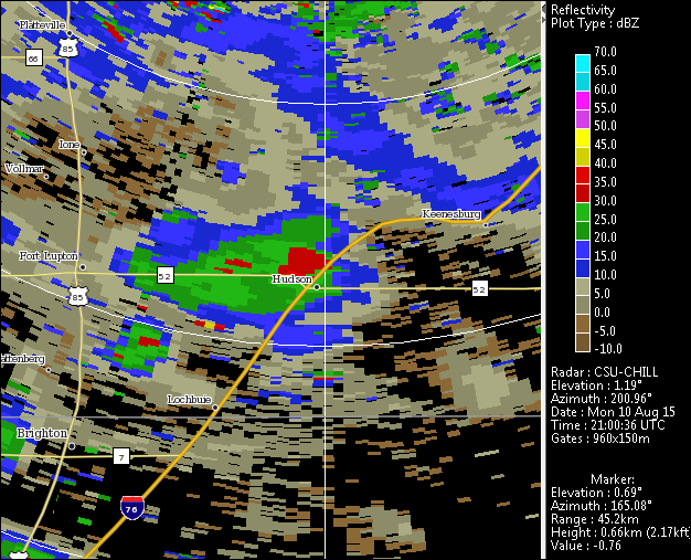
==Reflectivity loop== | ==Reflectivity loop== | ||
Maximum reflectivity values increased from ~30 dBZ to ~55 dBZ over the course of the image loop. The initial reflectivity core was located in the southern portion of the echo region near the town of Hudson in frame 2 (2105 UTC), with a larger-area high reflectivity area developing in the western portion of the echo along state highway 52 by frame 5 (2119 UTC). | |||
<center> | <center> | ||
| Line 15: | Line 16: | ||
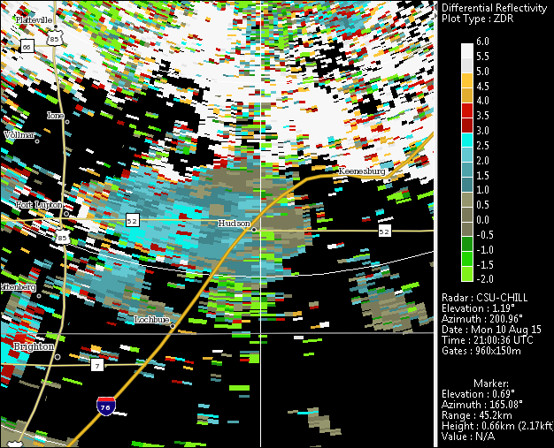
==Differential reflectivity loop== | ==Differential reflectivity (Zdr) loop== | ||
<center> | <center> | ||
The differential reflectivity values became distinctly positive (4 - 5 dB) in the developing high reflectivity cores. This indicates that the reflectivity-weighted mean height / width ratio of the hydrometeors was very small (i.e., oblate, flattened drop shapes). Rain drop size sorting often occurs in developing convective rain shafts when updraft speeds are large enough to retard the Earth-relative fall speed of the smaller, lower terminal velocity drops. As a result, only the larger diameter portion of drop population is initially able to reach the surface. Since these larger diameter drops have the most oblate equilibrium shapes, Zdr values are quite positive. | |||
<imgloop delay=500 imgprefix="http://www.chill.colostate.edu/anim/feb_2016_10aug2015_tstm_DSD/" width=626 height=507> | <imgloop delay=500 imgprefix="http://www.chill.colostate.edu/anim/feb_2016_10aug2015_tstm_DSD/" width=626 height=507> | ||
ZDR.CHL20150810_205905 GFC_3 PPI Sweep 01 Plot 0.png | ZDR.CHL20150810_205905 GFC_3 PPI Sweep 01 Plot 0.png | ||
Revision as of 07:07, 27 January 2016
Overview
During the afternoon hours of 10 August 2015 scattered thunderstorms in the greater Greeley Colorado area developed in a low vertical wind shear environment. Observations of these storms were conducted by the CSU-CHILL radar using 360 degree surveillance scan volumes with three low elevation angles. These volumes repeated with a cycle time of approximately 4.5 minutes. The thunderstorm of interest developed ~40 km south-southwest of the radar. The dual polarization data from this storm indicated that the drop size distribution in the precipitation shaft evolved with time. This evolution is seen the the following image loops assembled from the X.X deg elevation data in the 2059 - 2118 UTC time period. The data are from the 10 cm wavelength / S-band channel of the CSU-CHILL radar; 30 and 45 km range rings are shown in each loop frame.
Reflectivity loop
Maximum reflectivity values increased from ~30 dBZ to ~55 dBZ over the course of the image loop. The initial reflectivity core was located in the southern portion of the echo region near the town of Hudson in frame 2 (2105 UTC), with a larger-area high reflectivity area developing in the western portion of the echo along state highway 52 by frame 5 (2119 UTC).
|
|
||
|
Differential reflectivity (Zdr) loop
The differential reflectivity values became distinctly positive (4 - 5 dB) in the developing high reflectivity cores. This indicates that the reflectivity-weighted mean height / width ratio of the hydrometeors was very small (i.e., oblate, flattened drop shapes). Rain drop size sorting often occurs in developing convective rain shafts when updraft speeds are large enough to retard the Earth-relative fall speed of the smaller, lower terminal velocity drops. As a result, only the larger diameter portion of drop population is initially able to reach the surface. Since these larger diameter drops have the most oblate equilibrium shapes, Zdr values are quite positive.
|
|
||
|
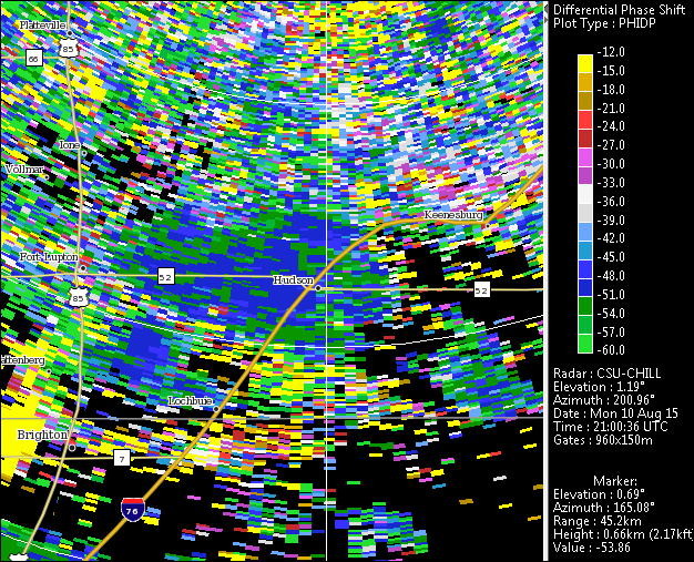
Differential propagation phase loop
|
|
||
|
RHI scan data

