DPWX/Zdr and phidp variations in a developing rain shaft: 10 August 2015
Author: Patrick C. Kennedy

Low elevation angle CSU-CHILL PPI scan through a developing thunderstorm precipitation shaft on 10 August 2015. The most positive Zdr values (white contour) are displaced towards the leading edge of the storm by drop size sorting effects. Plots depicting the evolving dual polarization characteristics of this precipitation area have been prepared.
Overview
During the afternoon hours of 10 August 2015 scattered thunderstorms in the greater Greeley Colorado area developed in a low vertical wind shear environment. Storm motion was towards the northeast at a few meters per second. Observations of these storms were conducted by the CSU-CHILL radar using 360 degree surveillance scan volumes with three low elevation angles. These volumes repeated with a cycle time of approximately 4.5 minutes. The thunderstorm of interest developed ~40 km south-southwest of the radar. The dual polarization data from this storm indicated that the drop size distribution in the precipitation shaft evolved with time. This evolution is seen the the following image loops assembled from the 0.7 deg elevation data in the 2059 - 2118 UTC time period. The data are from the 10 cm wavelength / S-band channel of the CSU-CHILL radar; 30 and 45 km range rings are shown in each loop frame.
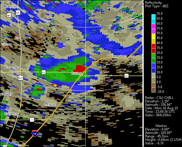
Reflectivity loop
Maximum reflectivity values increased from ~30 dBZ to ~55 dBZ over the course of the image loop. The initial reflectivity core was located in the southern portion of the echo region near the town of Hudson in frame 2 (2105 UTC), with a larger-area high reflectivity area developing in the western portion of the echo along state highway 52 by frame 5 (2119 UTC).
|
|
||
|
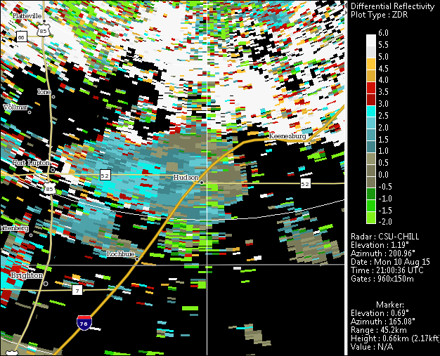
Differential reflectivity (Zdr) loop
The differential reflectivity values became distinctly positive (4 - 5 dB) in the developing high reflectivity cores. This indicates that the reflectivity-weighted mean height / width ratio of the hydrometeors was very small (i.e., oblate, flattened drop shapes). Rain drop size sorting often occurs in developing convective rain shafts when updraft speeds are large enough to retard the Earth-relative fall speed of the smaller, lower terminal velocity drops. As a result, only the larger diameter portion of drop population is initially able to reach the surface. Since these larger diameter drops have the most oblate equilibrium shapes, Zdr values are quite positive (Kumjian and Ryzhkov, JAS 2012, p 2042-2060.).
|
|
||
|
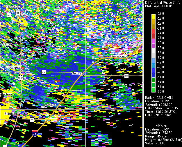
Differential propagation phase loop
Unlike Zdr, differential propagation phase (phidp) is sensitive to raindrop concentration as well as oblateness. Evidence of this can be seen in the somewhat delayed appearance of significant phidp shifts relative to the development of highly positive Zdr. In this case, appreciable color scale excursions in phidp do not begin to occur until frame 4 (~2113 UTC) as the drop concentrations are increasing in the maturing precipitation shaft.
|
|
||
|
RHI scan data
A few RHI scans were done through the storm immediately following the PPI sequence shown above. Some of the storm's structural features in the vertical plane are shown in the following example RHI sweep. In the first plot, the color fill is reflectivity with the 0.5 and 1.5 deg / km specific differential propagation phase (Kdp) contours overlaid. The storm's vertical extent is modest with a maximum height of ~8 km AGL (9.4 km MSL). The existence of the slightly elevated Kdp maximum suggests that the maximum rain rates had not yet reached the surface. (Melting and drop shedding from graupel particles may have also contributed to this elevated Kdp maximum).

The next plot shows the same sweep with the radial velocity indicated by the color fill and the 50 and 55 dBZ contours drawn as white contours. The enhanced inbound (negative) radial velocities appear to be deflecting the precipitation shaft towards the radar at lower height levels. This vertical wind shear has the effect of advecting the smaller, lower terminal velocity drops further away the main precipitation shaft. This local reduction in the smaller diameter portion of the raindrop size spectrum also contributes to enhanced positive Zdr at the leading edge of the precipitation shaft (Kumjian and Ryzhkov, JAS 2012, p 2042-2060.)

Summary
Despite the relatively small vertical stature, non-severe nature of this storm, evidence of drop size sorting could be found in the developing precipitation shaft of the 10 August 2015 storm. The implied short time and space scale changes in the rain drop size distribution have significant impacts on local visibility and rain rate conditions beneath developing thunderstorms. These rapidly changing conditions can be hazardous to both airborne and surface-based transportation activities.