DPWX/Large hail near Briggsdale: 6 August 2018: Difference between revisions
Pat kennedy (talk | contribs) No edit summary |
Pat kennedy (talk | contribs) (Starting text entry.) |
||
| Line 1: | Line 1: | ||
==Overview== | |||
Severe thunderstorms that produced damaging hail affected a number of locations in the eastern plains of Colorado and Wyoming on 6 August 2018. One such hailstorm caused significant damage and injuries at a zoo near Colorado Springs. At closer range to the CSU-CHILL radar, large, damaging hail was reported around 1630 MDT near the town of Briggsdale, Colorado (located approximately 35 km to the northeast of the radar). The CSU-CHILL radar collected primarily low elevation angle PPI sector scans as the hailstorm affected the Briggsdale area. The transmitter used in the horizontal polarization channel of the radar's S-band system was out of service during this operation. As a result, Linear Depolarization Ratio (LDR) was the only polarimetric variable available at S-band. The dual polarization X-band system was operating normally. | |||
==Damage survey summary== | |||
A brief damage survey was conducted in the greater Briggsdale area on the morning after the storm. While this area is sparsely populated, several instances of punctured home siding, broken windows, significant tree leaf removal, etc. were found. The following plot shows the locations of the hail damage observations: | |||
[[Image:6aug2018 picture locations RHI.png|center]] | [[Image:6aug2018 picture locations RHI.png|center]] | ||
Survey plot annotations: | |||
* 1,2,3: Photograph locations | |||
* SPC: Spotter report of 2.75 inch diameter hail at XXXX UTC Y miles SW of Briggsdale | |||
* W: Cracked truck windshield | |||
* L: Leaf debris beneath isolated trees | |||
* ND: No visible damage | |||
| Line 15: | Line 28: | ||
==S-band data== | ==S-band data== | ||
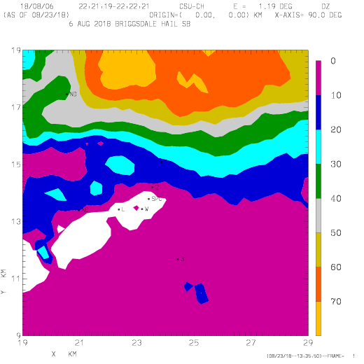
The following loop shows the V polarization reflectivity data from the 1.2 degree elevation PPI sweeps conducted as the storm passed the Briggsdale area. The damage survey points are included. The loop duration is ~20 minutes; during the majority of the loop the time interval between the frames is ~1 minute and 10 seconds. Reflectivity levels in excess of 70 dBZ affected most of the points where evidence of large hail was confirmed. | |||
Reflectivity | |||
<center> | <center> | ||
| Line 39: | Line 51: | ||
</center> | </center> | ||
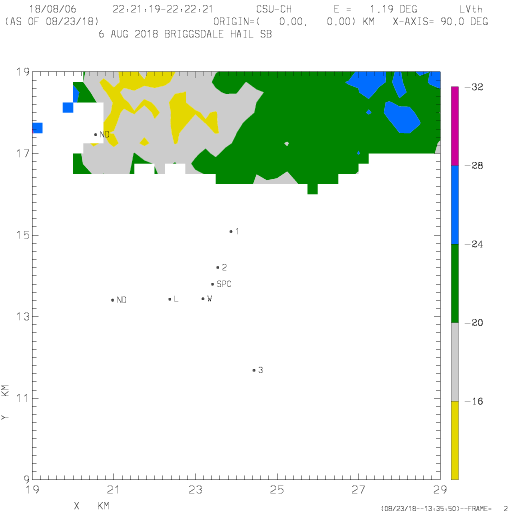
LDR | The next loop shows the corresponding LDR data (where the cross-polar signal is in the horizontal polarization received signal). To remove noise contamination, a reflectivity threshold of 35 dBZ has been applied to the LDR data. The non-spherical shapes and highly variable orientations of the hailstones contribute significant (> -20 dB) LDR levels. | ||
<center> | <center> | ||
| Line 61: | Line 73: | ||
</imgloop> | </imgloop> | ||
</center> | </center> | ||
The final loop contains the correlation coefficient (rhoHV) data observed at X-band. The data have been thresholded at an SNR level of +15 dB; they have also been scaled up by a factor of 10. Significant fluctuations in correlation occur even on the approximately one minute time step between sweeps. Brief correlation reductions below 0.8 affected several of the damage points. | |||
X-Band rhoHV X 10 loop | X-Band rhoHV X 10 loop | ||
Revision as of 06:16, 27 August 2018
Overview
Severe thunderstorms that produced damaging hail affected a number of locations in the eastern plains of Colorado and Wyoming on 6 August 2018. One such hailstorm caused significant damage and injuries at a zoo near Colorado Springs. At closer range to the CSU-CHILL radar, large, damaging hail was reported around 1630 MDT near the town of Briggsdale, Colorado (located approximately 35 km to the northeast of the radar). The CSU-CHILL radar collected primarily low elevation angle PPI sector scans as the hailstorm affected the Briggsdale area. The transmitter used in the horizontal polarization channel of the radar's S-band system was out of service during this operation. As a result, Linear Depolarization Ratio (LDR) was the only polarimetric variable available at S-band. The dual polarization X-band system was operating normally.
Damage survey summary
A brief damage survey was conducted in the greater Briggsdale area on the morning after the storm. While this area is sparsely populated, several instances of punctured home siding, broken windows, significant tree leaf removal, etc. were found. The following plot shows the locations of the hail damage observations:

Survey plot annotations:
- 1,2,3: Photograph locations
- SPC: Spotter report of 2.75 inch diameter hail at XXXX UTC Y miles SW of Briggsdale
- W: Cracked truck windshield
- L: Leaf debris beneath isolated trees
- ND: No visible damage


S-band data
The following loop shows the V polarization reflectivity data from the 1.2 degree elevation PPI sweeps conducted as the storm passed the Briggsdale area. The damage survey points are included. The loop duration is ~20 minutes; during the majority of the loop the time interval between the frames is ~1 minute and 10 seconds. Reflectivity levels in excess of 70 dBZ affected most of the points where evidence of large hail was confirmed.
|
|
||
|
The next loop shows the corresponding LDR data (where the cross-polar signal is in the horizontal polarization received signal). To remove noise contamination, a reflectivity threshold of 35 dBZ has been applied to the LDR data. The non-spherical shapes and highly variable orientations of the hailstones contribute significant (> -20 dB) LDR levels.
|
|
||
|
The final loop contains the correlation coefficient (rhoHV) data observed at X-band. The data have been thresholded at an SNR level of +15 dB; they have also been scaled up by a factor of 10. Significant fluctuations in correlation occur even on the approximately one minute time step between sweeps. Brief correlation reductions below 0.8 affected several of the damage points.
X-Band rhoHV X 10 loop
|
|
||
|
RHI data
S-band


X-band

