DPWX/Large hail near Briggsdale: 6 August 2018
Author: Patrick C. Kennedy

CSU-CHILL data at both S and X-bands was collected from a severe thunderstorm that produced large, damaging hail near the town of Briggsdale, Colorado during the afternoon of 6 August 2018. Selected radar data plots have been generated from the time period when hail damage occurred.
Overview
Severe thunderstorms that produced damaging hail affected a number of locations in the eastern plains of Colorado and Wyoming on 6 August 2018. One such hailstorm caused significant damage and injuries at a zoo near Colorado Springs. At closer range to the CSU-CHILL radar, large, damaging hail was reported around 1630 MDT near the town of Briggsdale, Colorado (located approximately 35 km to the northeast of the radar). The CSU-CHILL radar collected primarily low elevation angle PPI sector scans as the hailstorm affected the Briggsdale area. The transmitter used in the horizontal polarization channel of the radar's S-band system was out of service during this operation. As a result, Linear Depolarization Ratio (LDR) was the only polarimetric variable available at S-band. The dual polarization X-band system was operating normally.
Damage survey summary
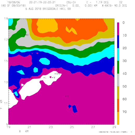
A brief damage survey was conducted in the greater Briggsdale area on the morning after the storm. While this area is sparsely populated, several instances of punctured home siding, broken windows, significant tree leaf removal, etc. were found. The following plot shows the locations of the hail damage observations:

Survey plot annotations:
- 1,2,3: Photograph locations
- SPC: Spotter report of 2.75 inch diameter hail at 2230 UTC 5 miles SSW of Briggsdale
- W: Cracked truck windshield
- L: Leaf debris beneath isolated trees
- ND: No visible damage


S-band data
The following loop shows the V polarization reflectivity data from the 1.2 degree elevation PPI sweeps conducted as the storm passed the Briggsdale area. The damage survey points are included. The loop duration is ~20 minutes; during the majority of the loop the time interval between the frames is ~1 minute and 10 seconds. Reflectivity levels in excess of 70 dBZ affected most of the points where the presence of large hail was confirmed.
|
|
||
|
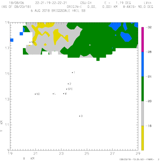
The next loop shows the corresponding LDR data (where the cross-polar signal is in the horizontal polarization received signal). To remove noise contamination, a reflectivity threshold of 40 dBZ has been applied to the LDR data. The non-spherical shapes and highly variable orientations of the hailstones contribute to the significantly enhanced (> -20 dB) LDR levels.
|
|
||
|
The final loop contains the correlation coefficient (rhoHV) data observed at X-band. The data have been thresholded at an SNR level of +15 dB; they have also been scaled up by a factor of 10. Significant fluctuations in correlation occur even on the approximately one minute time step between sweeps. Brief correlation reductions below 0.8 affected several of the damage points. The occurrence of differential propagation phase shift upon scattering (delta) can significantly lower correlation (Balakrishnan and Zrnic, JAS, 1990. p. 1525-1540.) The generation of large delta magnitudes increases as the radar backscattering moves from the Rayleigh regime into the Mie region. This scattering regime transition occurs as the hydrometeor effective backscattering diameter becomes a significant fraction of the radar wavelength. The ~2 inch (5 cm) maximum hailstone diameters in the Briggsdale area exceeded the ~3 cm X-band wavelength, so Mie scattering effects are likely.
X-Band rhoHV X 10 loop
|
|
||
|
RHI data
An RHI scan was done on an azimuth of 051 degrees at 2223 UTC. This scan was done just before the storm reached the damage survey area; the location of this RHI is shown in this article's initial plot. The first three plots show S-band data.
The storm's vertical structure contained an intense reflectivity core and an echo summit of ~ 14 km AGL. (The radar site elevation is 1.4 km MSL).

The corresponding radial velocity field has an intense divergence signature associated with the echo summit. The storm inflow / updraft area sloped into the echo core above the downdraft / outflow zone indicated by the negative (inbound) radial velocities in the near-range portion of the storm. (Above the ~25 km range mark).

A maximum in the cross-polar signal level due to the presence of hail was signified by the enhanced LDR levels that appeared in a large portion of the echo core.

The final two plots show selected X-band data from the same RHI scan. A well-organized rhoHV minimum existed in the 4 to 9 km AGL height band in the main updraft. (rhoHV has again been thresholded at an SNR of +15 dB.) This reduced correlation feature was probably due to growing hailstones that were large enough to generate Mie scattering effects at X-band. Less severely reduced correlation magnitudes also reached down to the surface where a rain-hail mixture occurred in the above freezing temperatures.

The final plot shows the X-band differential propagation phase (phidp) data. One feature of interest is the localized region of positive phase shift that has been marked in the updraft region. This positive phidp "bump" is the representation of differential propagation phase shift upon scattering (delta; Tromel et al., JAMC 2013, p. 2529-2548.) The delta column is well-correlated with the elevated rhoHV minimum. At heights below the freezing level, the presence of high concentrations of oblate raindrops results in significant positive phase accumulations with range. Color scale progressions in the opposite sense (i.e., light blue to dark blue) seen in some of the upper levels indicate that strong electric fields are rotating planar ice crystals towards a vertical orientation.

Acknowledgements: The author greatly appreciates the observational data that the local residents provided during the post-storm survey. Their cooperative attitude despite having experienced significant property damage was remarkable.