Template:Featured Article/July, 2013: Difference between revisions
From CSU-CHILL
Pat kennedy (talk | contribs) (initial posting) |
Pat kennedy (talk | contribs) No edit summary |
||
| Line 1: | Line 1: | ||
[[Image:17jun2013 2205 lobe anot.png|300px|right]] | [[Image:17jun2013 2205 lobe anot.png|300px|right]] | ||
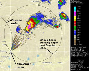
17 June 2013 CSU-CHILL S-Band reflectivity data in a 0.5 degree elevation angle PPI scan through a thunderstorm located in the east lobe of the dual Doppler network formed with the Pawnee radar. At higher altitudes, a Bounded Weak Echo Region (BWER) was present in this storm. Selected three dimensional wind fields from the BWER area have been prepared. | 17 June 2013 CSU-CHILL S-Band reflectivity data in a 0.5 degree elevation angle PPI scan through a thunderstorm located in the east lobe of the dual Doppler network formed with the Pawnee radar. At higher altitudes, a Bounded Weak Echo Region (BWER) was present in this storm. Selected three dimensional wind fields from the BWER area have been prepared. | ||
'''[[Dual-Doppler observations of a Bounded Weak Echo Region (BWER): | '''[[Dual-Doppler observations of a Bounded Weak Echo Region (BWER): 17 June 2013|more]]''' | ||
Latest revision as of 14:21, 26 June 2013

17 June 2013 CSU-CHILL S-Band reflectivity data in a 0.5 degree elevation angle PPI scan through a thunderstorm located in the east lobe of the dual Doppler network formed with the Pawnee radar. At higher altitudes, a Bounded Weak Echo Region (BWER) was present in this storm. Selected three dimensional wind fields from the BWER area have been prepared. more