Template:Featured Image/September, 2016: Difference between revisions
From CSU-CHILL
Pat kennedy (talk | contribs) (Posting Sept. 2016 image) |
Pat kennedy (talk | contribs) (Image replaced with correct date annotation (24 May, not 25 May).) |
||
| Line 1: | Line 1: | ||
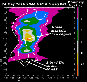
{{POTM|image= | {{POTM|image=24may2016 Windsor X Kdp S Zh anot.png|200px|title=Large X-band Kdp.|credit=Patrick Kennedy|text=Color filled plot of one-way X-band Kdp observed by the CSU-CHILL radar in a thunderstorm producing heavy rain near Windsor, Colorado. S-band reflectivity contours (white lines) depict the general storm core configuration.}} | ||
Latest revision as of 15:22, 12 September 2016

|
Large X-band Kdp. Color filled plot of one-way X-band Kdp observed by the CSU-CHILL radar in a thunderstorm producing heavy rain near Windsor, Colorado. S-band reflectivity contours (white lines) depict the general storm core configuration. Photo credit: Patrick Kennedy |