Aircraft targets as seen by the CSU-CHILL radar: 16 March 2011: Difference between revisions
Pat kennedy (talk | contribs) No edit summary |
m (Minor corrections, added to Featured Article category) |
||
| Line 1: | Line 1: | ||
[[Image:Aircraft anot 1.png|250px|right]] | |||
[[Image:Aircraft anot 1.png|250px| | |||
Low elevation angle PPI scans detected many aircraft targets in the vicinity of Denver International Airport on 16 March 2011. The echoes received from aircraft are generally considered to be a corrupting factor in meteorological analyses of radar data. | Low elevation angle PPI scans detected many aircraft targets in the vicinity of Denver International Airport on 16 March 2011. The echoes received from aircraft are generally considered to be a corrupting factor in meteorological analyses of radar data. | ||
==Introduction== | ==Introduction== | ||
To make high-resolution observations of precipitation systems, weather radars typically use antennas that generate narrow ( | To make high-resolution observations of precipitation systems, weather radars typically use antennas that generate narrow (1 to 3 degree wide) main beam patterns. Despite the use of these narrow "pencil" beams, weather radars still occasionally illuminate flying aircraft. During the afternoon of 16 March 2011, the CSU-CHILL radar conducted a continuous series of narrow PPI sector scans at an elevation angle of 0.95 degrees centered over Denver International Airport. This scanning regime provided numerous examples of aircraft targets. | ||
==Reflectivity== | ==Reflectivity== | ||
The following loop contains | The following loop contains about 22 minutes of data. The aircraft typically appear as single-gate targets. Due to the physical expansion of the radar pulse volume with range, the aircraft echoes are elongated in the cross-beam direction. The reflectivities vary as the aircraft climb and descend through PPI scan plane: | ||
<center> | <center> | ||
<imgloop delay=100 imgprefix="http://www.chill.colostate.edu/anim/16mar2011_aircraft/" width=640 height=512> | <imgloop delay=100 imgprefix="http://www.chill.colostate.edu/anim/16mar2011_aircraft/" width=640 height=512> | ||
| Line 98: | Line 104: | ||
==Differential Reflectivity== | ==Differential Reflectivity== | ||
Aircraft present unpredictable polarimetric characteristics due to their large, complicated shapes (in comparison to raindrops); they can also maneuver into varying orientations, change landing gear positions, etc. The H and V signal returns from aircraft are also affected by the target's position within the antenna beam pattern. In the following loop, letters mark the successive positions of two example aircraft. Their | Aircraft present unpredictable polarimetric characteristics due to their large, complicated shapes (in comparison to raindrops); they can also maneuver into varying orientations, change landing gear positions, etc. The H and V signal returns from aircraft are also affected by the target's position within the antenna beam pattern. In the following loop, letters mark the successive positions of two example aircraft. Their <math>Z_{dr}</math> values go through significant fluctuations. | ||
<center> | <center> | ||
<imgloop delay=200 imgprefix="http://www.chill.colostate.edu/anim/16mar2011_aircraft/" width=640 height=512> | <imgloop delay=200 imgprefix="http://www.chill.colostate.edu/anim/16mar2011_aircraft/" width=640 height=512> | ||
| Line 112: | Line 118: | ||
</imgloop> | </imgloop> | ||
</center> | </center> | ||
==Summary== | |||
Despite the use of narrow beam antennas, occasional contamination from aircraft may appear in weather radar data sets. Users of weather radar data should be aware that aircraft echoes may be present. | |||
[[Category:Featured Articles]] | |||
Latest revision as of 15:37, 22 March 2011

Low elevation angle PPI scans detected many aircraft targets in the vicinity of Denver International Airport on 16 March 2011. The echoes received from aircraft are generally considered to be a corrupting factor in meteorological analyses of radar data.
Introduction
To make high-resolution observations of precipitation systems, weather radars typically use antennas that generate narrow (1 to 3 degree wide) main beam patterns. Despite the use of these narrow "pencil" beams, weather radars still occasionally illuminate flying aircraft. During the afternoon of 16 March 2011, the CSU-CHILL radar conducted a continuous series of narrow PPI sector scans at an elevation angle of 0.95 degrees centered over Denver International Airport. This scanning regime provided numerous examples of aircraft targets.
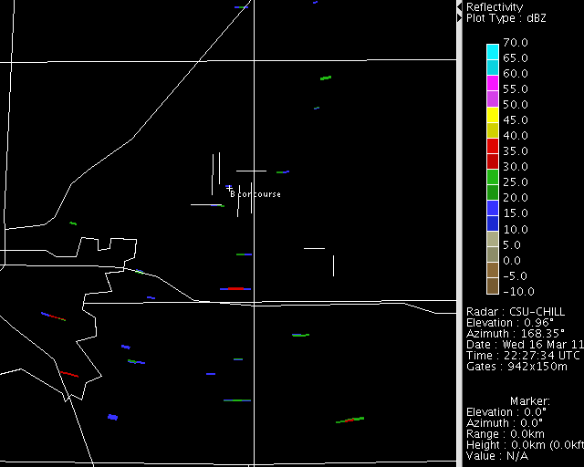
Reflectivity
The following loop contains about 22 minutes of data. The aircraft typically appear as single-gate targets. Due to the physical expansion of the radar pulse volume with range, the aircraft echoes are elongated in the cross-beam direction. The reflectivities vary as the aircraft climb and descend through PPI scan plane:
|
|
||
|
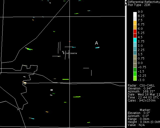
Differential Reflectivity
Aircraft present unpredictable polarimetric characteristics due to their large, complicated shapes (in comparison to raindrops); they can also maneuver into varying orientations, change landing gear positions, etc. The H and V signal returns from aircraft are also affected by the target's position within the antenna beam pattern. In the following loop, letters mark the successive positions of two example aircraft. Their values go through significant fluctuations.

|
|
||
|
Summary
Despite the use of narrow beam antennas, occasional contamination from aircraft may appear in weather radar data sets. Users of weather radar data should be aware that aircraft echoes may be present.