Template:Featured Article/November, 2017: Difference between revisions
From CSU-CHILL
Pat kennedy (talk | contribs) (Developing front page material for the November, 2017 article.) |
Pat kennedy (talk | contribs) (wording improvement) |
||
| Line 1: | Line 1: | ||
[[Image:KCYS 12jun2017 2209 0.9 PPI DZ anot.png|300px|right]] | [[Image:KCYS 12jun2017 2209 0.9 PPI DZ anot.png|300px|right]] | ||
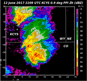
Severe thunderstorms as observed in the reflectivity field in a 0.9 deg elevation surveillance scan done by the NWS Cheyenne WY radar at 2208 UTC on 12 June 2017. Radial velocity data from this KCYS volume was combined with CSU-CHILL velocity data collected at the same time to synthesize the horizontal wind field at the anvil level of this storm complex. | Severe thunderstorms as observed in the reflectivity field in a 0.9 deg elevation angle surveillance scan done by the NWS Cheyenne WY radar at 2208 UTC on 12 June 2017. Radial velocity data from this KCYS volume was combined with CSU-CHILL velocity data collected at the same time to synthesize the horizontal wind field at the anvil level of this storm complex. | ||
('''[[DPWX/Dual Doppler analysis of horizontal winds in a thunderstorm anvil: 12 June 2017. |Full Article...]]''') | ('''[[DPWX/Dual Doppler analysis of horizontal winds in a thunderstorm anvil: 12 June 2017. |Full Article...]]''') | ||
Latest revision as of 10:13, 31 October 2017

Severe thunderstorms as observed in the reflectivity field in a 0.9 deg elevation angle surveillance scan done by the NWS Cheyenne WY radar at 2208 UTC on 12 June 2017. Radial velocity data from this KCYS volume was combined with CSU-CHILL velocity data collected at the same time to synthesize the horizontal wind field at the anvil level of this storm complex. (Full Article...)