Template:Featured Article/July, 2011: Difference between revisions
From CSU-CHILL
Pat kennedy (talk | contribs) (initial posting) |
Pat kennedy (talk | contribs) No edit summary |
||
| Line 1: | Line 1: | ||
[[Image:6aug2010 2234 HDR Kdp anot.png|250px|right]] | [[Image:6aug2010 2234 HDR Kdp anot.png|250px|right]] | ||
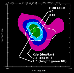
CSU-CHILL radar data indicating that both hail (positive HDR) and heavy rain ( | CSU-CHILL radar data indicating that both hail (positive Hail Differential Reflectivity; HDR) and heavy rain (large specific differential propagation phase; Kdp) are present in a low elevation PPI sweep through a thunderstorm. A series of plots documenting the time evolution of this hail / rain mixture have been prepared. | ||
'''[[Polarimetric radar identification of frozen hydrometeors in thunderstorm precipitation: 6 August 2010|(more)]]''' | '''[[Polarimetric radar identification of frozen hydrometeors in thunderstorm precipitation: 6 August 2010|(more)]]''' | ||
Latest revision as of 05:58, 25 June 2011

CSU-CHILL radar data indicating that both hail (positive Hail Differential Reflectivity; HDR) and heavy rain (large specific differential propagation phase; Kdp) are present in a low elevation PPI sweep through a thunderstorm. A series of plots documenting the time evolution of this hail / rain mixture have been prepared. (more)