WXlog/20080809 Thunderstorm RHI Vr: Difference between revisions
From CSU-CHILL
Pat kennedy (talk | contribs) (Created page with "An RHI scan was made through the core of a severe thunderstorm located southeast of the CHILL radar. Maximum echo tops were ~16 km AGL (17.4 km / 57 kft MSL). The unfolded r...") |
Pat kennedy (talk | contribs) No edit summary |
||
| Line 1: | Line 1: | ||
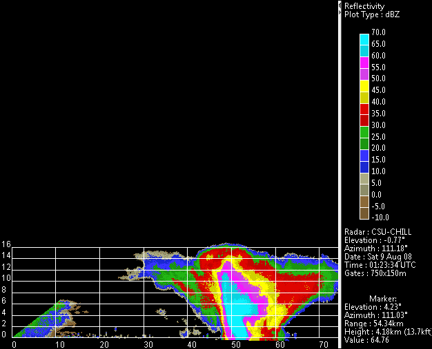
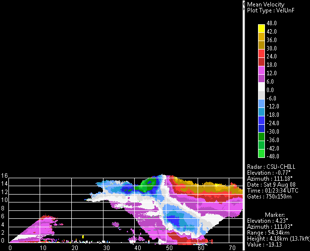
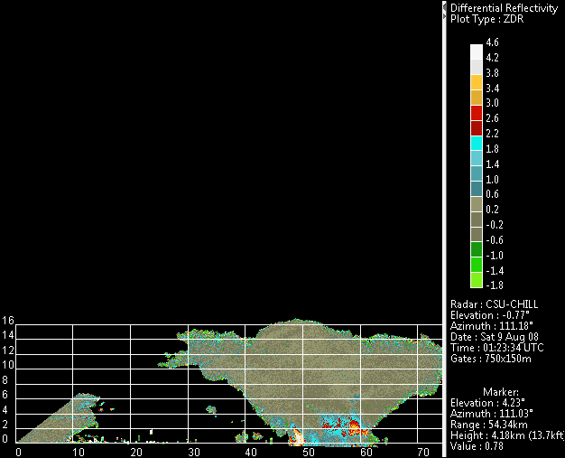
An RHI scan was made through the core of a severe thunderstorm located southeast of the CHILL radar. Maximum echo tops were ~16 km AGL (17.4 km / 57 kft MSL). The unfolded radial velocity | An RHI scan was made through the core of a severe thunderstorm located southeast of the CHILL radar. SPC storm reports show an observation of 0.75 inch hail, heavy rain and strong winds due to this storm at Wiggins at 0136 UTC. Maximum echo tops were ~16 km AGL (17.4 km / 57 kft MSL). The unfolded radial velocity pattern shows strong divergence centered on the echo summit. This upper level divergence is driven by an intense, sloping updraft. A Zdr hail signature is seen at ~53 km range in the echo core at near-ground heights. | ||
[[Image:9aug2008 tstm updraft rhi z.png|center]] | [[Image:9aug2008 tstm updraft rhi z.png|center]] | ||
Latest revision as of 07:00, 26 March 2020
An RHI scan was made through the core of a severe thunderstorm located southeast of the CHILL radar. SPC storm reports show an observation of 0.75 inch hail, heavy rain and strong winds due to this storm at Wiggins at 0136 UTC. Maximum echo tops were ~16 km AGL (17.4 km / 57 kft MSL). The unfolded radial velocity pattern shows strong divergence centered on the echo summit. This upper level divergence is driven by an intense, sloping updraft. A Zdr hail signature is seen at ~53 km range in the echo core at near-ground heights.


