WXlog/20180121 Snowband: Difference between revisions
From CSU-CHILL
Pat kennedy (talk | contribs) (Created page with "==Projects== S. Yuter 20hr B. Notaros SMAS ==Data Recording Period== 21 Jan 2018 1040:23 UTC to 21 Jan 2018 2121:11 UTC ==Summary== At start of ops, well-defined snowband with...") |
Pat kennedy (talk | contribs) (Added data image.) |
||
| (3 intermediate revisions by 2 users not shown) | |||
| Line 5: | Line 5: | ||
21 Jan 2018 1040:23 UTC to | 21 Jan 2018 1040:23 UTC to | ||
21 Jan 2018 2121:11 UTC | 21 Jan 2018 2121:11 UTC | ||
==Summary== | ==Summary== | ||
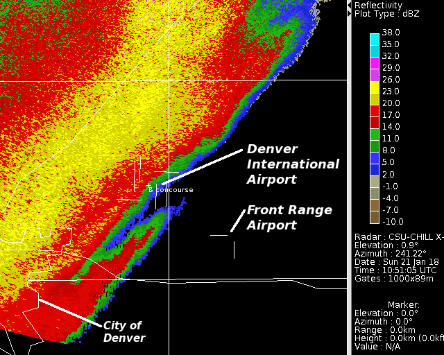
At start of ops, well-defined snowband with ~SW - NE orientation from just south of CHILL to metro Denver area. Lighter intensity echo / snowfall had general coverage behind (to the NW) of this initial band. During the +/- 2 hours of sunrise period, primarily RHI scans were done for the Yuter project. Once this period had past, low elevation PPI sectors and two sweep RHI scans centered on the | [[Image:21jan2018 104935 XB z anot.png|center]] | ||
At start of ops, well-defined snowband with ~SW - NE orientation from just south of CHILL to metro Denver area. Lighter intensity echo / snowfall had general coverage behind (to the NW) of this initial band. During the +/- 2 hours of sunrise period, primarily RHI scans were done for the Yuter project. Once this period had past, low elevation PPI sectors and two sweep RHI scans centered on the Easton - Valley View SMAS camera site were done. During the mid-morning local hours, an area of intensifying low-level reflectivity affected the Easton site. | |||
[[Category:Snowband]] | |||
[[Category:SMAS]] | |||
Latest revision as of 05:57, 10 March 2018
Projects
S. Yuter 20hr B. Notaros SMAS
Data Recording Period
21 Jan 2018 1040:23 UTC to 21 Jan 2018 2121:11 UTC
Summary

At start of ops, well-defined snowband with ~SW - NE orientation from just south of CHILL to metro Denver area. Lighter intensity echo / snowfall had general coverage behind (to the NW) of this initial band. During the +/- 2 hours of sunrise period, primarily RHI scans were done for the Yuter project. Once this period had past, low elevation PPI sectors and two sweep RHI scans centered on the Easton - Valley View SMAS camera site were done. During the mid-morning local hours, an area of intensifying low-level reflectivity affected the Easton site.