Template:Featured Image/March, 2016: Difference between revisions
From CSU-CHILL
Pat kennedy (talk | contribs) (Posting March 2016 image) |
Pat kennedy (talk | contribs) (Wording corrections.) |
||
| Line 1: | Line 1: | ||
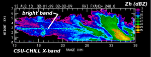
{{POTM|image=13aug2013 XB bband anot.png|200px|title=Stratiform and convective | {{POTM|image=13aug2013 XB bband anot.png|200px|title=Stratiform and convective radar echo.|credit=Patrick Kennedy|text=CSU-CHILL X-band reflectivity in an RHI scan through light rain and rain showers on 13 August 2013. Enhanced reflectivity in the melting layer (the bright band) is visible in the stratiform echo at ranges less than ~28 km. The stronger vertical motions and wider variety of hydrometeor diameters in the shower activity beyond 28 km range disrupt the bright band signature.}} | ||
Latest revision as of 10:14, 25 February 2016

|
Stratiform and convective radar echo. CSU-CHILL X-band reflectivity in an RHI scan through light rain and rain showers on 13 August 2013. Enhanced reflectivity in the melting layer (the bright band) is visible in the stratiform echo at ranges less than ~28 km. The stronger vertical motions and wider variety of hydrometeor diameters in the shower activity beyond 28 km range disrupt the bright band signature. Photo credit: Patrick Kennedy |