Template:Featured Image/June, 2009: Difference between revisions
From CSU-CHILL
Pat kennedy (talk | contribs) (Initial posting.) |
m (Fixed typos) |
||
| Line 1: | Line 1: | ||
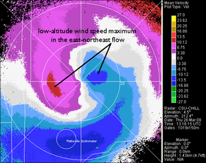
{{POTM|image=Web jun09 vel anot.png|title= | {{POTM|image=Web jun09 vel anot.png|title=Low-level Radial Velocity Maximum|credit=Pat Kennedy|text=Low level wind maxima are often observed in the CSU-CHILL data during deep cyclonic upslope winter precipitation events in northeastern Colorado. The radial velocity pattern shown here occurred during the early stages of a blizzard on 26 March, 2009}} | ||
Latest revision as of 13:11, 1 June 2009

|
Low-level Radial Velocity Maximum Low level wind maxima are often observed in the CSU-CHILL data during deep cyclonic upslope winter precipitation events in northeastern Colorado. The radial velocity pattern shown here occurred during the early stages of a blizzard on 26 March, 2009 Photo credit: Pat Kennedy |