Gust front collision: 2 July 2010: Difference between revisions
Pat kennedy (talk | contribs) (loop posting) |
Pat kennedy (talk | contribs) No edit summary |
||
| Line 1: | Line 1: | ||
==Introduction== | |||
Low-level convergence is commonly enhanced along thunderstorm gust fronts. This convergence can be further increased by interactions between gust fronts. Under suitable vertical stratifications of moisture and instability, gust front-related convergence can initiate the development showers and thunderstorms. During the afternoon of 2 July 2010, the CSU-CHILL radar was making low elevation PPI scans at time intervals of ~ 4 minutes. While these scans were in progress, the collision of two gust fronts was observed. Following this collision, a thunderstorm developed in the immediate vicinity of Denver International Airport. | |||
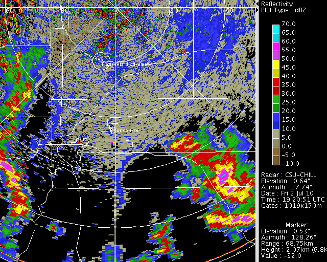
== Reflectivity loop== | == Reflectivity loop== | ||
Reflectivity "fine lines" marked the locations of the two gust interacting gust fronts. Convergence along these gust fronts locally collects the insects that are present in the undisturbed boundary layer. The increased insect concentrations result in a stronger radar reflectivity level. | |||
<center> | <center> | ||
<imgloop delay=400 imgprefix="http://www.chill.colostate.edu/anim/2jul2010_gf_collision/" width=640 height=512> | <imgloop delay=400 imgprefix="http://www.chill.colostate.edu/anim/2jul2010_gf_collision/" width=640 height=512> | ||
| Line 36: | Line 40: | ||
</center> | </center> | ||
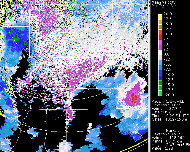
==Radial velocity loop== | ==Radial velocity loop== | ||
Converging radial velocity patterns were commonly present along the fine lines; especially in the vicinity of the collision area. | |||
<center> | <center> | ||
<imgloop delay=400 imgprefix="http://www.chill.colostate.edu/anim/2jul2010_gf_collision/" width=640 height=512> | <imgloop delay=400 imgprefix="http://www.chill.colostate.edu/anim/2jul2010_gf_collision/" width=640 height=512> | ||
| Line 72: | Line 77: | ||
</center> | </center> | ||
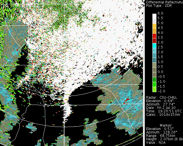
==Differential Reflectivity Loop== | ==Differential Reflectivity Loop== | ||
Differential reflectivity values are quite positive (> ~+5 dB) in the insect echo regions. This is due to the highly oblate body shapes that insects typically present. A pulse of positive Zdr values can also be seen during the intense phase of the thunderstorm over KDEN. | |||
<center> | <center> | ||
<imgloop delay=400 imgprefix="http://www.chill.colostate.edu/anim/2jul2010_gf_collision/" width=640 height=512> | <imgloop delay=400 imgprefix="http://www.chill.colostate.edu/anim/2jul2010_gf_collision/" width=640 height=512> | ||
Revision as of 09:44, 30 July 2010
Introduction
Low-level convergence is commonly enhanced along thunderstorm gust fronts. This convergence can be further increased by interactions between gust fronts. Under suitable vertical stratifications of moisture and instability, gust front-related convergence can initiate the development showers and thunderstorms. During the afternoon of 2 July 2010, the CSU-CHILL radar was making low elevation PPI scans at time intervals of ~ 4 minutes. While these scans were in progress, the collision of two gust fronts was observed. Following this collision, a thunderstorm developed in the immediate vicinity of Denver International Airport.
Reflectivity loop
Reflectivity "fine lines" marked the locations of the two gust interacting gust fronts. Convergence along these gust fronts locally collects the insects that are present in the undisturbed boundary layer. The increased insect concentrations result in a stronger radar reflectivity level.
|
|
||
|
Radial velocity loop
Converging radial velocity patterns were commonly present along the fine lines; especially in the vicinity of the collision area.
|
|
||
|
Differential Reflectivity Loop
Differential reflectivity values are quite positive (> ~+5 dB) in the insect echo regions. This is due to the highly oblate body shapes that insects typically present. A pulse of positive Zdr values can also be seen during the intense phase of the thunderstorm over KDEN.
|
|
||
|