Damaging hailstorm at Denver International Airport: 13 July 2011: Difference between revisions
Pat kennedy (talk | contribs) (initial posting) |
Pat kennedy (talk | contribs) (grammer corrections) |
||
| Line 1: | Line 1: | ||
==Introduction== | ==Introduction== | ||
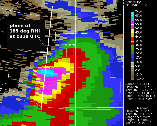
A monsoon circulation pattern significantly increased the | A monsoon circulation pattern significantly increased the tropospheric moisture content in the CSU-CHILL radar coverage area during the first half of July 2011. Thunderstorms frequently developed in this environment, with the more intense cells producing locally flooding rains and damaging hail. One such strong storm directly impacted Denver International Airport (KDEN) near 2130 MDT (0330 on 14 July on UTC). The following reflectivity PPI plot shows the location of the echo core as the storm approached the airport from the south-southwest at 0320 UTC: | ||
[[Image:14jul2011 0320 z anot.png|center]] | [[Image:14jul2011 0320 z anot.png|center]] | ||
==RHI Data== | ==RHI Data== | ||
| Line 7: | Line 7: | ||
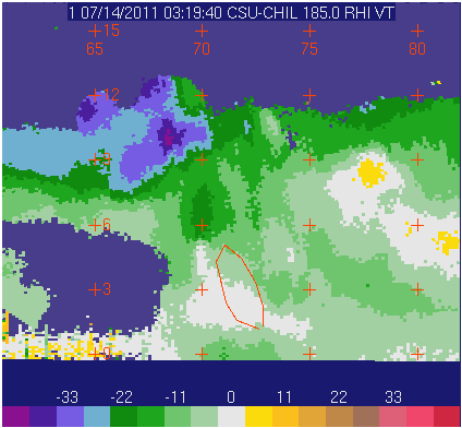
Above the echo core, strong divergence was indicated in the unfolded radial velocity pattern associated with the overshooting echo top located at a range of ~68 km: | Above the echo core, strong divergence was indicated in the unfolded radial velocity pattern associated with the overshooting echo top located at a range of ~68 km: | ||
[[Image:Png.1110714031940.CSU-CHIL.0 185.0 RHI VT.png|center]] | [[Image:Png.1110714031940.CSU-CHIL.0 185.0 RHI VT.png|center]] | ||
Enhanced Linear Depolarization Ratio (Ldr) values reaching ~ -20 dB in much of mid-tropospheric reflectivity core. (This area is marked by the irregular boundary in all of the RHI plots). The presence of hailstones growing in this region | Enhanced Linear Depolarization Ratio (Ldr) values reaching ~ -20 dB were present in much of mid-tropospheric reflectivity core. (This area is marked by the irregular boundary in all of the RHI plots). The presence of hailstones growing in this region probably increased the cross-polar received signal level. (Gates with a cross-polar SNR below +10 dB have been removed). | ||
[[Image:Png.1110714031940.CSU-CHIL.0 185.0 RHI LT.png|center]] | [[Image:Png.1110714031940.CSU-CHIL.0 185.0 RHI LT.png|center]] | ||
The quasi-spherical, tumbling hailstones | The quasi-spherical, tumbling hailstones produced a local reduction in Differential Reflectivity (Zdr) at low altitudes near a range of 72 km. | ||
[[Image:Png.1110714031940.CSU-CHIL.0 185.0 RHI DR.png|center]] | [[Image:Png.1110714031940.CSU-CHIL.0 185.0 RHI DR.png|center]] | ||
==PPI Data== | ==PPI Data== | ||
| Line 16: | Line 16: | ||
The corresponding differential reflectivity data contained an extensive near 0 dB hail signature in much of the high reflectivity region: | The corresponding differential reflectivity data contained an extensive near 0 dB hail signature in much of the high reflectivity region: | ||
[[Image:14jul2011 0330 vchill zdr.png|center]] | [[Image:14jul2011 0330 vchill zdr.png|center]] | ||
Due to condensation and melting, the outer surfaces of the hailstones were probably at least slightly wet. This physical state in combination with | Due to condensation and melting, the outer surfaces of the hailstones were probably at least slightly wet. This physical state in combination with the stone's tumbling motions produced a distinct Ldr maximum in the hail region: | ||
[[Image:14jul2011 0330 vchill ldr.png|center]] | [[Image:14jul2011 0330 vchill ldr.png|center]] | ||
The diverse range of particle sizes and shapes due to the mixture of raindrops and hailstones also lead to a local reduction in rhoHV: | The diverse range of particle sizes and shapes due to the mixture of raindrops and hailstones also lead to a local reduction in rhoHV: | ||
[[Image:14jul2011 0330 vchill rho.png|center]] | [[Image:14jul2011 0330 vchill rho.png|center]] | ||
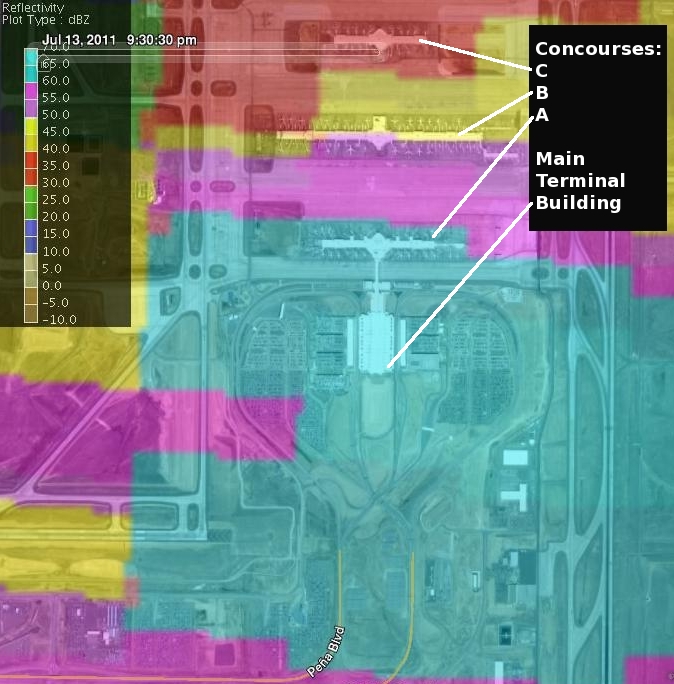
In the following image, the VCHILL software has been used to overlay the 0330 UTC reflectivity data with a Google Earth view of the airport. Intense (>60 dBZ) reflectivity levels | In the following image, the VCHILL software has been used to overlay the 0330 UTC reflectivity data with a Google Earth view of the airport. Intense (>60 dBZ) reflectivity levels moved over many of the aircraft parking areas at the terminal concourses. Schedule disruptions continued for several days after this storm as aircraft were removed from service while hail damage was identified and repaired. | ||
[[Image:GE 14jul2011 0330 KDEN z anot.jpg|center]] | [[Image:GE 14jul2011 0330 KDEN z anot.jpg|center]] | ||
[[Category:Featured Articles]] | |||
[[Category:Hail]] | |||
Revision as of 10:56, 28 July 2011
Introduction
A monsoon circulation pattern significantly increased the tropospheric moisture content in the CSU-CHILL radar coverage area during the first half of July 2011. Thunderstorms frequently developed in this environment, with the more intense cells producing locally flooding rains and damaging hail. One such strong storm directly impacted Denver International Airport (KDEN) near 2130 MDT (0330 on 14 July on UTC). The following reflectivity PPI plot shows the location of the echo core as the storm approached the airport from the south-southwest at 0320 UTC:
RHI Data
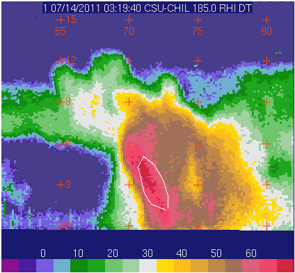
Reflectivity levels in excess of 50 dBZ were centered aloft in the forward portion of the storm:
Above the echo core, strong divergence was indicated in the unfolded radial velocity pattern associated with the overshooting echo top located at a range of ~68 km:
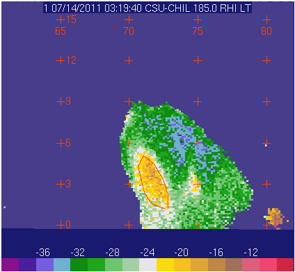
Enhanced Linear Depolarization Ratio (Ldr) values reaching ~ -20 dB were present in much of mid-tropospheric reflectivity core. (This area is marked by the irregular boundary in all of the RHI plots). The presence of hailstones growing in this region probably increased the cross-polar received signal level. (Gates with a cross-polar SNR below +10 dB have been removed).
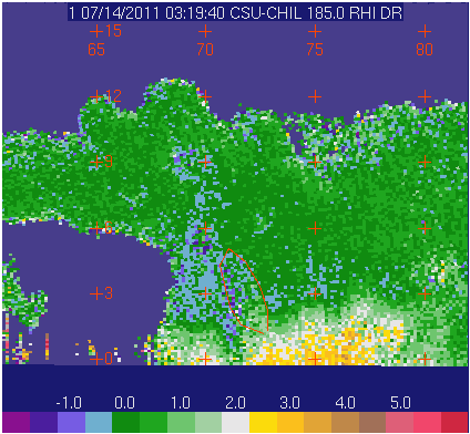
The quasi-spherical, tumbling hailstones produced a local reduction in Differential Reflectivity (Zdr) at low altitudes near a range of 72 km.
PPI Data
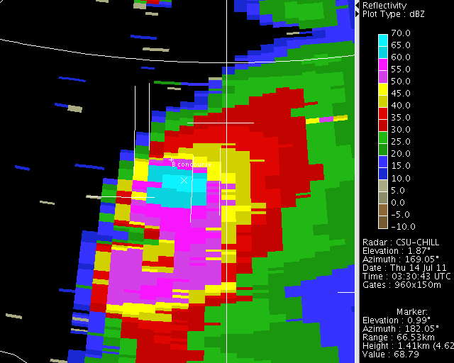
Approximately 10 minutes later at 0330 UTC, the storm was crossing the airport terminal area. The KDEN METAR observation at 0331 included hail and winds from 200 degrees at 44 knots gusting to 51 knots. Reflectivity levels of ~68 dBZ existed in the CHILL 1.0 degree elevation PPI data at this time:
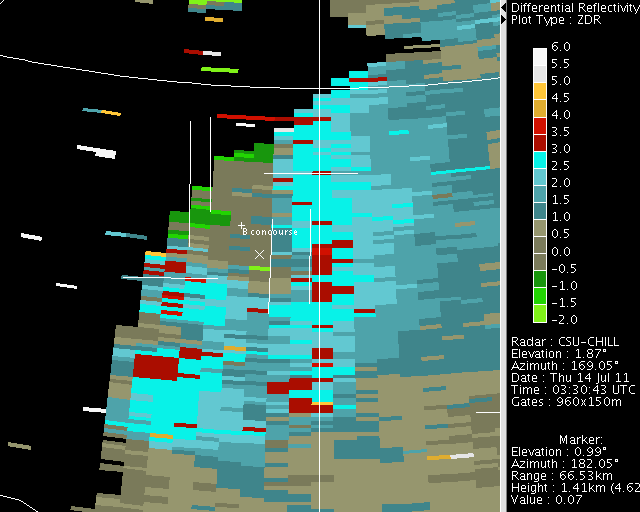
The corresponding differential reflectivity data contained an extensive near 0 dB hail signature in much of the high reflectivity region:
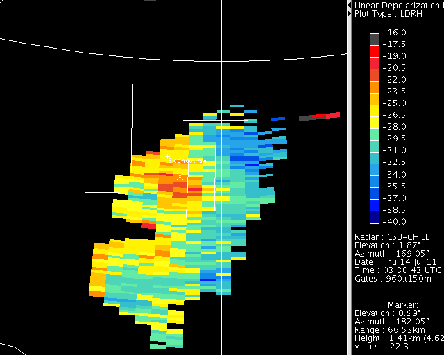
Due to condensation and melting, the outer surfaces of the hailstones were probably at least slightly wet. This physical state in combination with the stone's tumbling motions produced a distinct Ldr maximum in the hail region:
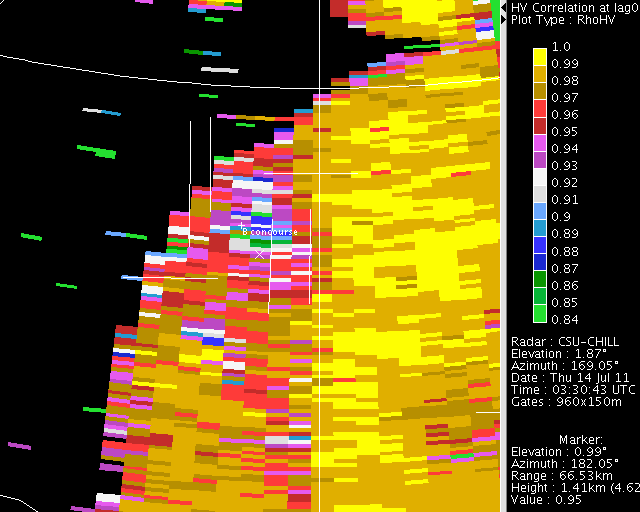
The diverse range of particle sizes and shapes due to the mixture of raindrops and hailstones also lead to a local reduction in rhoHV:
In the following image, the VCHILL software has been used to overlay the 0330 UTC reflectivity data with a Google Earth view of the airport. Intense (>60 dBZ) reflectivity levels moved over many of the aircraft parking areas at the terminal concourses. Schedule disruptions continued for several days after this storm as aircraft were removed from service while hail damage was identified and repaired.
