DPWX/Varying thunderstorm Zdr patterns: 13 June 2016: Difference between revisions
Pat kennedy (talk | contribs) (Adding X-Band contour overlay RHI plots.) |
Pat kennedy (talk | contribs) (Starting text additions.) |
||
| Line 1: | Line 1: | ||
==Overview== | |||
Multiple thunderstorms, some severe, occurred in the coverage area of the CSU-CHILL radar during the afternoon of 13 June 2016. Data was collected primarily using low-elevation angle PPI sector scans along with occasional two-sweep RHI volumes. One RHI sweep done at ~2305 UTC intercepted two separate thunderstorms with contrasting Zdr characteristics at near surface heights. The following PPI plot at 2307 UTC shows the general echo configuration. The two storms of interest, one at a range of 60 km and the second at 90 km range along the 141 degree azimuth are indicated. An outflow boundary was also present near the 60 km range storm. | |||
[[Image:13jun2016 2307 PPI Z anot.png|center]] | [[Image:13jun2016 2307 PPI Z anot.png|center]] | ||
S-band reflectivity | ==S-band PPI image loops== | ||
The next image loops show the history of the two storms of interest during the 2233 - 2307 UTC period as depicted by the 0.5 deg elevation reflectivity data. Both storms contained core reflectivities of ~60 dBZ. According to SPC storm reports, the southern storm produced 2.75 inch diameter hail 7 miles north of the town of Deer Trail at 2256 UTC. The northern (60 km range) storm was generally propagating along the outflow boundary. | |||
<center> | <center> | ||
| Line 15: | Line 19: | ||
</center> | </center> | ||
The corresponding radial velocity loop shows the outflow boundary related convergence along the southern edge of the nearer (60 km range) storm. | |||
<center> | <center> | ||
| Line 29: | Line 33: | ||
</center> | </center> | ||
==S-band RHI data at 2305 UTC== | |||
Selected plots from the 141 degree azimuth RHI sweep that intercepted both storms at 2305 UTC are shown below. The reflectivity core in the 90 km range storm extended down to the lowest observed heights, while the 60 km range storm featured an elevated reflectivity core: | |||
[[Image:13jun2016 2305 141 az Z anot.png|center]] | [[Image:13jun2016 2305 141 az Z anot.png|center]] | ||
Both storms showed indications of updraft-related divergence at echo top level. Low-level convergence was found near the southern edge of the 60 km range storm: | |||
[[Image:13jun2016 2305 141 az VT anot.png|center]] | [[Image:13jun2016 2305 141 az VT anot.png|center]] | ||
As marked in the following plot, the Zdr regimes at low levels in the two storms were quite different. The 90 km range storm contained an area of near 0 dB Zdr that reached down to the surface. This low Zdr / high reflectivity combination is typical of hail areas where quasi-spherical, tumbling hailstones tend to equalize the horizontally and vertically-polarized received signals. In the 60 km range storm, low level Zdr in the precipitation shaft was distinctly positive (+4 to +5 dB). These positive values indicate the presence of distinctly oblate hydrometeors, producing an H signal level that was appreciably stronger than the V received signal level. The updraft implied by the low level convergence in this area would tend to loft the smaller diameter, more spherical drops, leaving only the larger-diameter, more oblate portion of the drop size distribution. Also, melting small ice particles falling from the suspended reflectivity core probably had a melt water torus about their "equator", giving them a flattened shape. | |||
[[Image:13jun2016 2305 141 az Zdr anot.png|center]] | [[Image:13jun2016 2305 141 az Zdr anot.png|center]] | ||
==X-band rhoHV characteristics in the 60 km range storm== | |||
2305 UTC RHI | 2305 UTC RHI zoomed in on the 60 km storm; X-band rhoHV overlay on S-Band data: | ||
[[Image:13jun2016 S Zh X RH10 anot.png|center]] | [[Image:13jun2016 S Zh X RH10 anot.png|center]] | ||
Revision as of 17:37, 18 November 2016
Overview
Multiple thunderstorms, some severe, occurred in the coverage area of the CSU-CHILL radar during the afternoon of 13 June 2016. Data was collected primarily using low-elevation angle PPI sector scans along with occasional two-sweep RHI volumes. One RHI sweep done at ~2305 UTC intercepted two separate thunderstorms with contrasting Zdr characteristics at near surface heights. The following PPI plot at 2307 UTC shows the general echo configuration. The two storms of interest, one at a range of 60 km and the second at 90 km range along the 141 degree azimuth are indicated. An outflow boundary was also present near the 60 km range storm.

S-band PPI image loops
The next image loops show the history of the two storms of interest during the 2233 - 2307 UTC period as depicted by the 0.5 deg elevation reflectivity data. Both storms contained core reflectivities of ~60 dBZ. According to SPC storm reports, the southern storm produced 2.75 inch diameter hail 7 miles north of the town of Deer Trail at 2256 UTC. The northern (60 km range) storm was generally propagating along the outflow boundary.
|
|
||
|

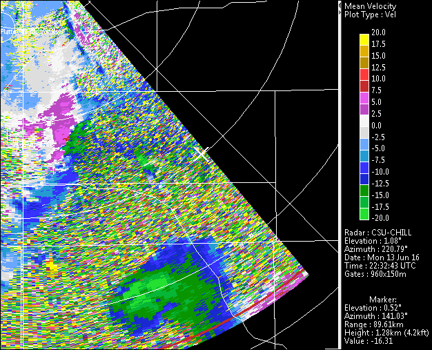
The corresponding radial velocity loop shows the outflow boundary related convergence along the southern edge of the nearer (60 km range) storm.
|
|
||
|
S-band RHI data at 2305 UTC
Selected plots from the 141 degree azimuth RHI sweep that intercepted both storms at 2305 UTC are shown below. The reflectivity core in the 90 km range storm extended down to the lowest observed heights, while the 60 km range storm featured an elevated reflectivity core:

Both storms showed indications of updraft-related divergence at echo top level. Low-level convergence was found near the southern edge of the 60 km range storm:

As marked in the following plot, the Zdr regimes at low levels in the two storms were quite different. The 90 km range storm contained an area of near 0 dB Zdr that reached down to the surface. This low Zdr / high reflectivity combination is typical of hail areas where quasi-spherical, tumbling hailstones tend to equalize the horizontally and vertically-polarized received signals. In the 60 km range storm, low level Zdr in the precipitation shaft was distinctly positive (+4 to +5 dB). These positive values indicate the presence of distinctly oblate hydrometeors, producing an H signal level that was appreciably stronger than the V received signal level. The updraft implied by the low level convergence in this area would tend to loft the smaller diameter, more spherical drops, leaving only the larger-diameter, more oblate portion of the drop size distribution. Also, melting small ice particles falling from the suspended reflectivity core probably had a melt water torus about their "equator", giving them a flattened shape.

X-band rhoHV characteristics in the 60 km range storm
2305 UTC RHI zoomed in on the 60 km storm; X-band rhoHV overlay on S-Band data:


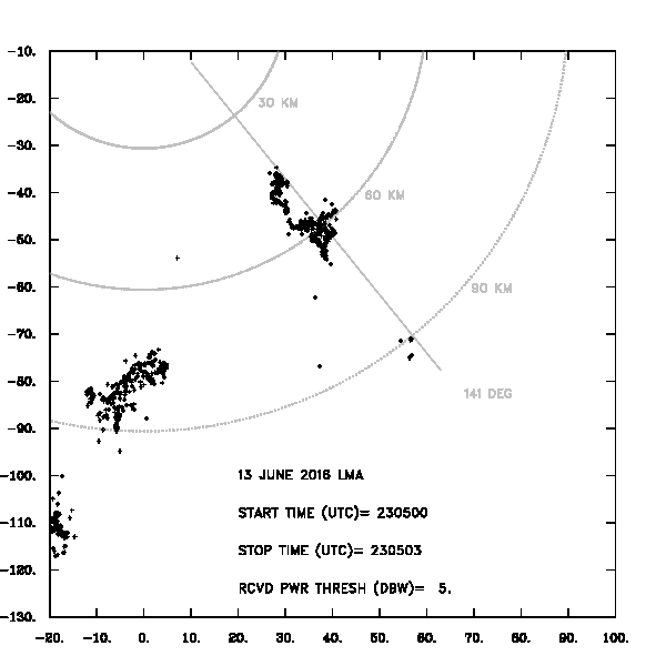
LMA data in 3 second time intervals for the minutes of 2305 and 2306 UTC on 13 June 2016.
|
|
||
|