DPWX/Near-surface hail development: 6 - 7 June 2016: Difference between revisions
Pat kennedy (talk | contribs) (Initial image posting) |
Pat kennedy (talk | contribs) No edit summary |
||
| Line 1: | Line 1: | ||
==Overview== | |||
Near 1800 MDT on 6 June 2016 (the UTC boundary between 6 and 7 June), the CSU-CHILL radar was conducting continuous surveillance scans at an elevation angle of 1.9 degrees. In this unattended precipitation mapping operating mode, the scans repeated at ~90 second intervals. This scan sequence captured the development of dual polarization hail signatures in a thunderstorm that was passing approximately 30 km to the southwest of the radar. | |||
==Reflectivity and differential reflectivity (Zdr) loop== | |||
The frames in the following CSU-CHILL data image loops were generated using the SOLO software developed at NCAR. Reflectivity is on the left and Zdr is on the right. The maximum reflectivity levels in the echo core at the 1.9 degree elevation angle reach ~70 dBZ at 00XX UTC. As this intensification took place, a three body scattering signature appeared in the down range direction. The backscattered return received by the radar is only one component of the three dimensional electromagnetic field that the hydrometeors emit when they are illuminated by the transmitted radar pulse. The re-radiation in the downward direction illuminates the underlying Earth surface. In turn, components of scattering from the ground surface can re-illuminate the hydrometeors in the pulse volume. Some of the radiation produced by this second illumination of the hydrometeors is in the original backscattering direction towards the radar. Due to the path length added by the round trip to and from the underlying surface (i.e., the three scattering path nodes are (i) hydrometeors, (ii) underlying surface, (iii) hydrometeors), the the radar plots the resultant "three body" echo at ranges beyond that of the generating storm (REF). | |||
The Zdr values in the echo core decrease from their initially positive values towards / slightly below 0 dB during this general intensification period. | |||
<center> | <center> | ||
Revision as of 06:07, 20 February 2018
Overview
Near 1800 MDT on 6 June 2016 (the UTC boundary between 6 and 7 June), the CSU-CHILL radar was conducting continuous surveillance scans at an elevation angle of 1.9 degrees. In this unattended precipitation mapping operating mode, the scans repeated at ~90 second intervals. This scan sequence captured the development of dual polarization hail signatures in a thunderstorm that was passing approximately 30 km to the southwest of the radar.
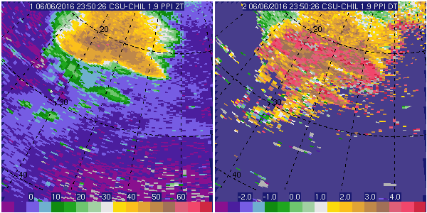
Reflectivity and differential reflectivity (Zdr) loop
The frames in the following CSU-CHILL data image loops were generated using the SOLO software developed at NCAR. Reflectivity is on the left and Zdr is on the right. The maximum reflectivity levels in the echo core at the 1.9 degree elevation angle reach ~70 dBZ at 00XX UTC. As this intensification took place, a three body scattering signature appeared in the down range direction. The backscattered return received by the radar is only one component of the three dimensional electromagnetic field that the hydrometeors emit when they are illuminated by the transmitted radar pulse. The re-radiation in the downward direction illuminates the underlying Earth surface. In turn, components of scattering from the ground surface can re-illuminate the hydrometeors in the pulse volume. Some of the radiation produced by this second illumination of the hydrometeors is in the original backscattering direction towards the radar. Due to the path length added by the round trip to and from the underlying surface (i.e., the three scattering path nodes are (i) hydrometeors, (ii) underlying surface, (iii) hydrometeors), the the radar plots the resultant "three body" echo at ranges beyond that of the generating storm (REF).
The Zdr values in the echo core decrease from their initially positive values towards / slightly below 0 dB during this general intensification period.
|
|
||
|