DPWX/Low level convergence in dual-Doppler winds: 7 May 2016: Difference between revisions
Pat kennedy (talk | contribs) (initial image posting May 2017 article.) |
Pat kennedy (talk | contribs) (Starting text development.) |
||
| Line 1: | Line 1: | ||
==Overview== | |||
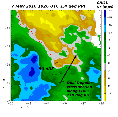
On 7 May 2016 an approaching synoptic scale trough was forecast to produce afternoon thunderstorms across much of northeastern Colorado. At low levels, a moist easterly flow regime was in place in much of the CSU-CHILL coverage area when radar operations began around mid-day. By approximately 1900 UTC, thunderstorms began to develop to the south of the radar. The following plot shows the radial velocity data observed in a 1.4 degree elevation scan that covered a small thunderstorm located approximately 60 km southwest of the radar. The black 50 dBZ contour shows the location of the thunderstorm reflectivity core. The red dots highlight the highly convergent characteristics of the wind field in much of the thunderstorm environment. (i.e. the zero radial velocity contour is oriented perpendicular to the radar azimuths with outbound (positive) values on the near-range side.) | |||
[[Image:AI 7may2016 1925 1.4deg ppi anot.png|center]] | [[Image:AI 7may2016 1925 1.4deg ppi anot.png|center]] | ||
==Dual Doppler winds in the 1923 UTC RHI scan== | |||
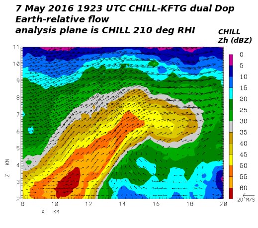
The CHILL radar did a two-sweep RHI scan through the thunderstorm at 1923 UTC. This scan was in adequate time synchronization with a volume scan that the NWS KFTG radar started at XXXX UTC. The radial velocities from these two radars were interpolated to a common set of Cartesian gridpoints and three dimensional wind components were synthesized using the NCAR CEDRIC software. These analysis results were then re-mapped onto a vertical plane that coincided with the CHILL RHI scan plane. (The location of this analysis plane is marked in the PPI plot that was shown above.) The vertical cross section results show the presence of an organized updraft associated with the low-level convergence zone. The combination of the updraft and the strengthening southwesterly synoptic flow aloft produce an overhanging reflectivity structure. | |||
Revision as of 05:31, 20 April 2017
Overview
On 7 May 2016 an approaching synoptic scale trough was forecast to produce afternoon thunderstorms across much of northeastern Colorado. At low levels, a moist easterly flow regime was in place in much of the CSU-CHILL coverage area when radar operations began around mid-day. By approximately 1900 UTC, thunderstorms began to develop to the south of the radar. The following plot shows the radial velocity data observed in a 1.4 degree elevation scan that covered a small thunderstorm located approximately 60 km southwest of the radar. The black 50 dBZ contour shows the location of the thunderstorm reflectivity core. The red dots highlight the highly convergent characteristics of the wind field in much of the thunderstorm environment. (i.e. the zero radial velocity contour is oriented perpendicular to the radar azimuths with outbound (positive) values on the near-range side.)
Dual Doppler winds in the 1923 UTC RHI scan
The CHILL radar did a two-sweep RHI scan through the thunderstorm at 1923 UTC. This scan was in adequate time synchronization with a volume scan that the NWS KFTG radar started at XXXX UTC. The radial velocities from these two radars were interpolated to a common set of Cartesian gridpoints and three dimensional wind components were synthesized using the NCAR CEDRIC software. These analysis results were then re-mapped onto a vertical plane that coincided with the CHILL RHI scan plane. (The location of this analysis plane is marked in the PPI plot that was shown above.) The vertical cross section results show the presence of an organized updraft associated with the low-level convergence zone. The combination of the updraft and the strengthening southwesterly synoptic flow aloft produce an overhanging reflectivity structure.
