DPWX/Initial Multiple Angle Snow Camera-Radar experiment (MASCRAD) project operations: 15 November 2014
CSU ECE personnel constructing a 2/3 scale DFIR (Double Fence Intercomparison Reference) wind screen for the ground instrumentation site at the Easton Valley View Airport in October, 2014:

Overview of the instruments installed inside the DFIR wind screen: (Walt Petersen / NASA credited for providing the 2DVD and Pluvio).

Close up view of the Multiple Angle Snow Camera:

NWS KFTG 0.5 degree elevation angle reflectivity loop.
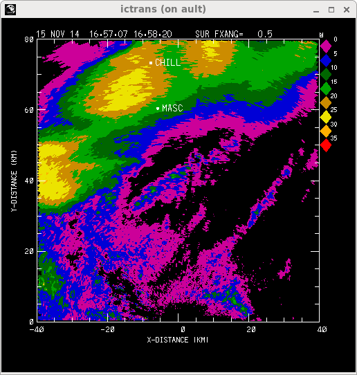
Reflectivity images at ~10 minute intervals as an area of snow passed the MASC site on Saturday, 15 November 2014:
|
|
||
|
Selected image from one of the MASC cameras at 1718:49 UTC on 15 November 2014. The snow particle is composed of an aggregation of a number of smaller planar ice crystals. The resultant composite ice / air particle has very low bulk density and an irregular shape.

CSU-CHILL RHI scan over the Easton Airport at approximately the same time as the particle image shown above. As height decreases towards the ground in the Easton area, reflectivity increases while differential reflectivity decreases from ~ +4 dB to ~ 0 dB. These radar patterns probably result as the fairly pristine ice crystals at echo top undergo collisions as they fall towards the ground, producing many aggregated particles near ground level. These irregularily-shaped, low density aggregates also generate very low (~ -35 dB) Linear Depolarization Ratio (Ldr) levels.

Subsequent MASCRAD data sets, including additional information from the NCAR's S-Pol radar and a portable sounding system, will be collected during the remainder of the winter months. The detailed 3D snow particle structures developed from the MASC images will allow accurate calculations of their microwave backscattering characteristics.