DPWX/Greeley hailstorm: 8 May 2017
Overview
Considerable severe weather activity occurred in northeastern Colorado on 8 May 2017, including widespread hail damage in the greater Denver area. A separate hailstorm moved across the Greeley area around 2200 UTC. In addition to hail, this storm produced also produced localized flooding in parts of Greeley as well as at the CSU-CHILL radar site. This storm track brought the storm to short ranges, allowing the CSU-CHILL radar to make detailed observations at both 11 and 3 cm wavelengths (S and X-band).
Dual Doppler analyses at 7.5 km MSL
The NWS KFTG WSR-88D radar began a volume scan at 213X UTC. (KFTG is located at azimuth 171X degrees and 7Y km from CHILL.) By coincidence, this volume started YY seconds ahead of the 213AA CSU-CHILL volume scan. At this time, the storm was located just southwest of the city of Greeley at a range of ~25 km from CHILL. According to SPC spotter reports, one inch diameter hail was reported 4 miles west of Greeley at 2130 UTC.
The following two plots show the air motion fields derived from a dual Doppler synthesis at the 7.5 km MSL height level. At this height level, a well-defined bounded weak echo region (BWER) was present. The horizontal wind field analysis shown in the first plot shows that locally accelerated flow occurred in the right and forward flank areas in the immediate vicinity of the BWER.

The second plot repeats the horizontal wind vectors while the color fill shows the vertical air motion obtained by downward integration of the horizontal divergence field. This integration direction was selected due to the storm's long range from KFTG; the ~75 km range from KFTG prevented this radar from collecting data within ~2 km of the surface. The vertical velocity pattern confirmed the presence of a strong updraft associated with the BWER. Updrafts in the 10 - 20 mps range are required to loft hydrometeors, producing the BWER (REF). The general updraft activity is also important to developing the high concentrations of supercooled liquid water that are important to hailstone growth. The horizontal wind vectors imply that hailstone embryos generated in cumulus towers in the storm's right flank were advected through the supercooled liquid water environment in the updraft area. This trajectory has been found to be effective in the growth of large hailstones (REF)

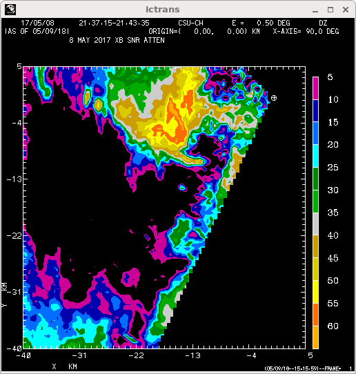
251 degree RHI data at 2135:47 UTC
Immediately following the volume scan associated with the dual Doppler analyses shown above, the CSU-CHILL radar conducted an RHI sweep through the BWER. The location of this scan (azimuth 251 degrees) is shown as a red line in the dual-Doppler plots. The black dot on this line depicts the BWER's 13 km range.

|
|
||
|