DPWX/Dual Doppler analysis of horizontal winds in a thunderstorm anvil: 12 June 2017: Difference between revisions
Pat kennedy (talk | contribs) No edit summary |
Pat kennedy (talk | contribs) No edit summary |
||
| Line 1: | Line 1: | ||
==Overview== | |||
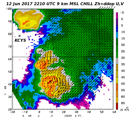
During the afternoon hours of 12 June 2017 several severe thunderstorms moved across the northwestern half of the CSU-CHILL coverage area. The Storm Prediction Center spotter reports included hailstone diameters of 4.25 inches near Pierce Colorado at 2200 UTC and confirmed tornado activity beginning just south of Hereford at 2250 UTC. CSU-CHILL radar observations of the thunderstorm activity was primarily done using PPI sector volume scans. Two sweep RHI volumes were also done to examine microphysically interesting areas. By coincidence, the CSU-CHILL and the NWS Cheyenne WSR-88D radars both started volume scans at 2208:47 UTC. This pair of synchronized volume scans were used as input to a dual Doppler analysis using the NCAR CEDRIC software package. This presentation primarily considers the dual-Doppler based horizontal wind field patterns in the anvil portion of the echo system. | |||
The following plot shows the the CSU-CHILL reflectivity and unfolded radial velocity fields in the 6.2 degree elevation sweep of the 2208:47 volume. This elevation angle intercepted both two intense reflectivity cores as well as their extensive downstream anvil echo. The radial velocities are almost entirely positive (i.e., away from the radar). The radial velocity magnitudes varied across the anvil region, with some areas exceeding +45 mps. | |||
[[Image:12jun2017 CHILL 6.2 VT anot.png|center]] | [[Image:12jun2017 CHILL 6.2 VT anot.png|center]] | ||
Revision as of 16:52, 27 October 2017
Overview
During the afternoon hours of 12 June 2017 several severe thunderstorms moved across the northwestern half of the CSU-CHILL coverage area. The Storm Prediction Center spotter reports included hailstone diameters of 4.25 inches near Pierce Colorado at 2200 UTC and confirmed tornado activity beginning just south of Hereford at 2250 UTC. CSU-CHILL radar observations of the thunderstorm activity was primarily done using PPI sector volume scans. Two sweep RHI volumes were also done to examine microphysically interesting areas. By coincidence, the CSU-CHILL and the NWS Cheyenne WSR-88D radars both started volume scans at 2208:47 UTC. This pair of synchronized volume scans were used as input to a dual Doppler analysis using the NCAR CEDRIC software package. This presentation primarily considers the dual-Doppler based horizontal wind field patterns in the anvil portion of the echo system.
The following plot shows the the CSU-CHILL reflectivity and unfolded radial velocity fields in the 6.2 degree elevation sweep of the 2208:47 volume. This elevation angle intercepted both two intense reflectivity cores as well as their extensive downstream anvil echo. The radial velocities are almost entirely positive (i.e., away from the radar). The radial velocity magnitudes varied across the anvil region, with some areas exceeding +45 mps.

|
|
||
|