Casebook 20 May 2004: Difference between revisions
Pat kennedy (talk | contribs) |
m (Added a few illustrations) |
||
| Line 8: | Line 8: | ||
[http://chill.colostate.edu/java/vchill.php?sweep=xlab.chill.colostate.edu:2510*/dsk/dnf/data/2004/05/21/%20DIR*CHL20040521_023028%20MPRHI1%20RHI*Sweep%2004¢er=0.,0.&range=100.&plot=dBZ example in VCHILL] | [http://chill.colostate.edu/java/vchill.php?sweep=xlab.chill.colostate.edu:2510*/dsk/dnf/data/2004/05/21/%20DIR*CHL20040521_023028%20MPRHI1%20RHI*Sweep%2004¢er=0.,0.&range=100.&plot=dBZ example in VCHILL] | ||
<gallery> | |||
Image:20040521_z_ppi.png|Reflectivity PPI | |||
Image:20040521_z_rhi.png|Reflectivity RHI through thunderstorm | |||
</gallery> | |||
[[Casebook 29 October 2003|prev]] [[Casebook 27 June 2004|next]] | [[Casebook 29 October 2003|prev]] [[Casebook 27 June 2004|next]] | ||
[[Category:Casebook|20040520]] | [[Category:Casebook|20040520]] | ||
[[Category:Weak Echo Region (WER)|20040520]] | [[Category:Weak Echo Region (WER)|20040520]] | ||
Latest revision as of 02:04, 29 March 2008
CSU-CHILL Casebook: 20 May, 2004
During the early evening hours of 20 May, 2004 (21 May on UTC), an isolated thunderstorm developed approximately 35 km south-southwest of the CSU-CHILL radar. This storm rapidly intensified; 1.5 inch diameter hail was reported at 0031 UTC. As the storm moved eastward into Morgan County, a weak echo region (WER) was evident in association with main updraft. (The locally encircled reflectivity minimum visible on PPI sweep 2 (azmiuth 101 degrees / range 76 km) was surmounted by a high reflectivity area on sweep 7. See the first two VCHILL example images below.) A thunderstorm RHI scan through the WER at 0230 UTC is shown in the third VCHILL example image. (Note: severe weather spotters reported a tornado 1 mile northwest of the city of Fort Morgan at 0229 UTC.)
-
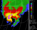
Reflectivity PPI
-
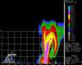
Reflectivity RHI through thunderstorm

