CSU CHILL: Difference between revisions

From CSU-CHILL

(Removed video and scan optimizer links)
(Removed webmail link, switched elog to new link)
Line 111: Line 111:
**[[VCHILL Download Instructions|Download Instructions]]
**[http://www.chill.colostate.edu/cgi-bin/user_service Sign up]
*[https://lab.chill.colostate.edu/webmail Webmail]
<!-- *[http://lab.chill.colostate.edu:8080  Elog System] -->
*[http://lab.chill.colostate.edu:8080 Elog System]
*[http://elog.chill.colostate.edu  Elog System]
<!-- *[http://pix.chill.colostate.edu/zm Live video] ([[Live video feed|More Info]]) -->
<!-- *[http://www.chill.colostate.edu/cgi-bin/web_antopt4  Scan Optimizer Tool] -->

Revision as of 13:21, 10 March 2020

National Weather Radar Facility
The CSU-CHILL National Weather Radar Facility, located in Greeley, CO, is an advanced, transportable dual-polarized dual-wavelength (S- and X-band) weather radar system. The facility is operated by Colorado State University, under the sponsorship of the National Science Foundation and the University.

Featured Article

RHI scan through the outflow / inflow interface of a severe thunderstorm on 21 June 2010. In addition to the Kelvin-Helmholtz circulations on this interface, dual-polarization indications of heavy rain, hail, etc. were also observed. (more)

Web Services

  • Real-time Images

Featured Image

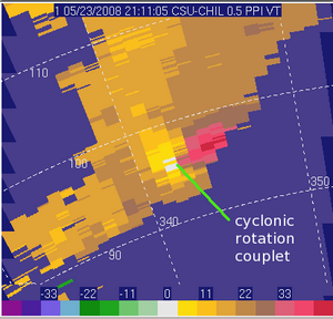
Tornadic Thunderstorm Tornadic Thunderstorm

A cyclonic rotation pattern was seen in the CSU-CHILL radial velocity data while a tornado was being reported just Northwest of Cheyenne, WY. The closer range KCYS WSR-88D data provides a more detailed view of the circulation and the associated hook echo.

Photo credit: Pat Kennedy
More featured pictures...


Upcoming Events