Bow echo in a convective line


Conceptual Summary
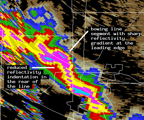
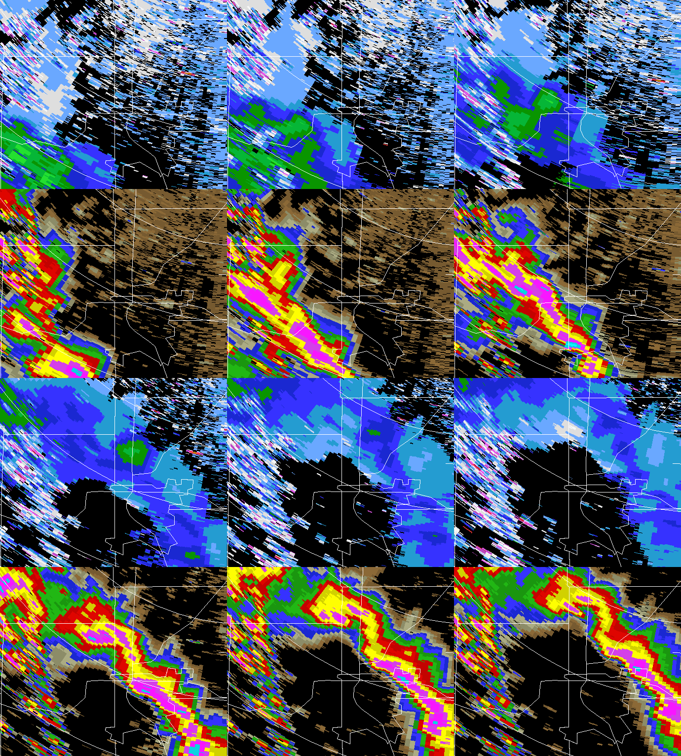
The basic characteristic of the "bow echo" pattern is a well-defined outward bulge in a convective echo's leading edge as seen in a low elevation angle reflectivity PPI display. Bow echoes can develop on size scales ranging from a few kilometers (individual convective cells) to ~100 km (squall lines; Lee et al., 1992). Damaging surface winds and tornado development have been observed to occur in association with bow echoes. The surface outflow in these echo systems is often enhanced by a rear inflow jet that impinges on the rear of the echo system at mid-tropospheric heights. The rear inflow jet brings environmental air into the echo system, promoting the evaporation and sublimation of the cloud particles. The resultant localized cooling can produce negative bouyancy and downdrafts that transport the momentum of the rear inflow jet to the surface (Przybylinski, 1995).
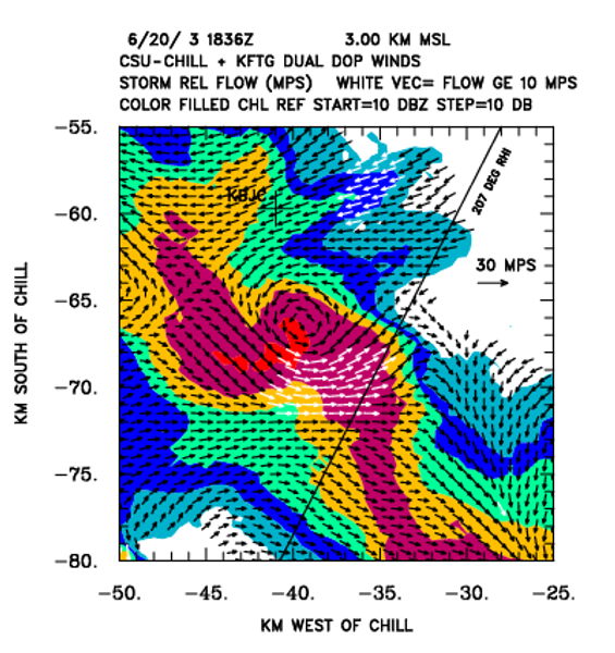
The plots shown above depict a small, non-severe bow echo that developed in a line of thunderstorms that moved off of the eastern foothills of the Rocky Mountains and crossed the greater Denver area. The formation and dissipation of the bow echo feature takes place during the ~45 minute image loop. A localized region of enhanced (strongly negative) inbound radial velocities is best developed when the leading edge reflectivity has the most distinct bow shape and a large horizontal reflectivity gradient. The horizontal wind field at 3 km MSL when the bow echo was well defined at 1836 UTC was determined from a dual Doppler synthesis combining the radial velocities observed by the CSU-CHILL and Denver / Front Range WSR-88D (KFTG). The plotted wind vectors have had the observed echo motion from 215 deg at 12.5 mps. (This storm motion vector was within 10 degrees of being directly towards the CSU-CHILL.) The bow echo is associated with a localized region of enhanced horizontal wind speeds. (The vector color is white when the storm-relative wind speed is 10 mps or greater.) A mesocyclone circulation is also present along the northern edge of the bow echo speed maximum. Numerical simulations have documented the association of such mesoscale vorticies with bow echo systems (particularly the larger scale squall line systems; Weisman, 1993).
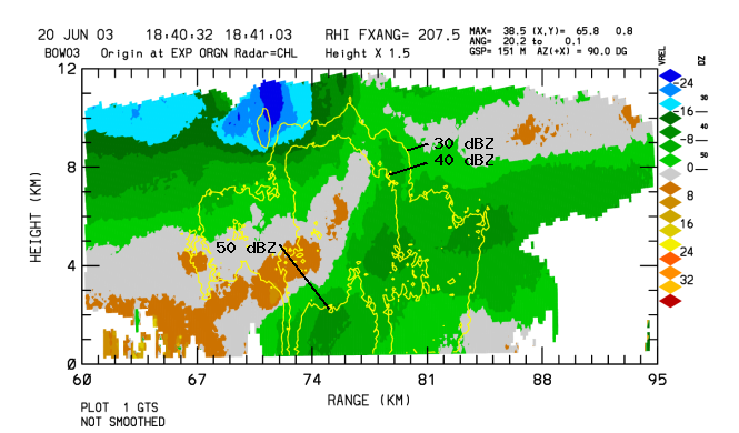
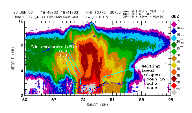
The RHI plots show the data collected by the CHILL radar in an RHI scan through the bow echo. The storm motion has been subtracted from the radial velocities. The storm's inflow / updraft structure is indicated by the region of positive radial velocities that curves upward from the lower heights at the leading edge of the storm to the diverging pattern near the 9 KM AGL height level. The rear inflow jet pattern is depicted by the enhanced velocities that slope from a height of 5-6 km at the rear edge of the storm to near surface heights at a range of 74 km. The solid contours in the final RHI plot show three increasingly positive Zdr levels. Positive Zdr values (H polarization reflectivity exceeding V polarization reflectivity) are expected when oblate raindrops are present. Positive Zdr values do not begin to appear until low heights are reached in the intense echo core. This implies that relatively large ice particles that require more time to completely melt as they descend are present in the precipition core. The cooling due to the melting ice probably strengthened the downdraft / outflow winds in the apex of the bow echo.
VCHILL
Main article: VCHILL
References
- Wen-Chau Lee, Roger M. Wakimoto and Richard E. Carbone. 1992: The Evolution and Structure of a "Bow-Echo-Microburst" Event. Part II: The Bow Echo. Monthly Weather Review: Vol. 120, No. 10, pp. 2211-2225.
- Ron W. Przybylinski. 1995: The Bow Echo: Observations, Numerical Simulations, and Severe Weather Detection Methods. Weather and Forecasting: Vol. 10, No. 2, pp. 203-218.
- Morris L. Weisman. 1993: The Genesis of Severe, Long-Lived Bow Echoes. Journal of the Atmospheric Sciences: Vol. 50, No. 4, pp. 645-670.
Acknowledgements: Morris Weisman provided a review of this presentation.