20070423 Polarimetric Observations of a Mesocyclone: Difference between revisions
No edit summary |
No edit summary |
||
| (One intermediate revision by the same user not shown) | |||
| Line 2: | Line 2: | ||
[[Image:Vr_crop_anot.png]] | [[Image:Vr_crop_anot.png]] | ||
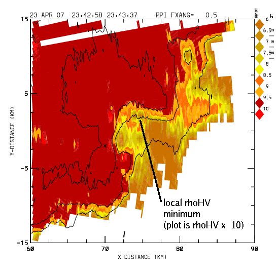
In the following plot the color fill is the | In the following plot the color fill is the <math>\rho_{HV}</math> data from the same sweep. (The basic <math>\rho_{HV}</math> values have been scaled up by a factor of 10; 8 = 0.8). One localized <math>\rho_{HV}</math> minimum is found near the Doppler rotation pattern. (Other investigators have found that tornado-lofted debris can cause localized <math>\rho_{HV}</math> minima). However, <math>\rho_{HV}</math> is also lowered in much of the strong outflow area. The <math>\rho_{HV}</math> estimator used in alternating HV mode operation is subject to error when the radial velocity power spectrum within the pulse volume is non-Gaussian. Such ill-behaved spectra (i.e., bi-modal, etc.) may be expected in the storm environment depicted here. Additional data sets are being collected to examine the differences between the <math>\rho_{HV}</math> estimates made under alternating H, V and simultaneous H+V transmission schemes. | ||
[[Image:Rh_crop_anot.png]] | [[Image:Rh_crop_anot.png]] | ||
[[Category:Recent Observations]] | [[Category:Recent Observations]] | ||
Latest revision as of 22:34, 25 October 2007
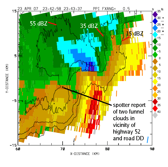
Low elevation angle PPI scan data were collected during the development of a severe thunderstorm over Morgan County, Colorado on the afternoon of 23 April, 2007. During this operation, the CSU-CHILL radar was operating in alternating H, V transmit polarization mode. The following plot shows unfolded radial velocities with color filled pixels and an overlay of three reflectivity contours. The elevation angle is 0.5 degrees. This sweep is essentially coincident with a report of two funnel clouds sighted by the Morgan County Sheriff. The radial velocity pattern contains both strong outflow and cyclonic rotation patterns:

In the following plot the color fill is the data from the same sweep. (The basic values have been scaled up by a factor of 10; 8 = 0.8). One localized minimum is found near the Doppler rotation pattern. (Other investigators have found that tornado-lofted debris can cause localized minima). However, is also lowered in much of the strong outflow area. The estimator used in alternating HV mode operation is subject to error when the radial velocity power spectrum within the pulse volume is non-Gaussian. Such ill-behaved spectra (i.e., bi-modal, etc.) may be expected in the storm environment depicted here. Additional data sets are being collected to examine the differences between the estimates made under alternating H, V and simultaneous H+V transmission schemes.

