DPWX/Greeley hailstorm: 8 May 2017
Author: Patrick C. Kennedy

CSU-CHILL S-band reflectivity data in a 2.4 degree elevation angle PPI scan through a severe thunderstorm that affected the city of Greeley, Colorado (and the CHILL radar site) on 8 May 2017. Both PPI volume and RHI scans confirmed the presence of a Bounded Weak Echo Region (BWER). Plots of selected CSU-CHILL data collected at both S and X-band from this storm have been assembled.
Overview
Considerable severe weather activity occurred in northeastern Colorado on 8 May 2017, including widespread hail damage in the greater Denver region. A separate hailstorm moved across the Greeley area around 2150 UTC. In addition to hail, this storm produced also produced localized flooding in parts of Greeley as well as at the CSU-CHILL radar site. This storm track brought the system to short ranges, allowing the CSU-CHILL radar to make detailed observations at both 11 and 3 cm wavelengths (S and X-band).
Dual Doppler analyses at 7.5 km MSL
The NWS KFTG WSR-88D radar began a volume scan at 2129:41 UTC. (KFTG is located at azimuth 173 degrees and 74 km from CHILL.) By coincidence, this volume started just 12 seconds before the 2129:53 UTC CSU-CHILL volume scan. At this time, the storm was located just southwest of the city of Greeley at a range of ~25 km from CHILL. According to SPC spotter reports, one inch diameter hail was reported 4 miles west of Greeley at 2130 UTC.
The following two plots show the air motion fields derived from a dual Doppler synthesis at the 7.5 km MSL height level. At this height, a well-defined bounded weak echo region (BWER) was present near X=-12, Y=-3 km from CHILL. The horizontal wind field analysis in the first plot shows that locally accelerated flow occurred in the right and forward flank areas in the immediate vicinity of the BWER.

The second plot repeats the horizontal wind vectors while the color fill shows the vertical air motion obtained by downward integration of the horizontal divergence field. This integration direction was selected due to the storm's long range from KFTG; the ~74 km range from KFTG prevented this radar from collecting data within ~2 km of the surface. The vertical velocity pattern confirmed the presence of a strong updraft associated with the BWER (Lemon and Doswell, MWR 1979, p1184-1197). Updrafts in the 10 - 20 mps range are required to loft the larger, higher reflectivity hydrometeors and produce the BWER. This general updraft activity is also important to developing the high concentrations of supercooled liquid water that are important to hailstone growth. The horizontal wind vectors imply that hailstone embryos generated in cumulus towers in the storm's right flank were advected through the supercooled liquid water environment in the updraft area. This one of the embryo trajectories that has been found to be effective in the growth of hailstones (Miller et al, JAS, 1990, p1619-1646).

251 degree RHI data at 2135:47 UTC
Immediately following the volume scan associated with the dual Doppler analyses shown above, the CSU-CHILL radar conducted an RHI sweep through the BWER. The location of this scan (azimuth 251 degrees) is shown as a red line in the dual-Doppler plots. The black dot on this line depicts the BWER's 13 km range.
The overhanging reflectivity structure is evident in the S-band reflectivity data (upper left panel). The associated Zdr data (upper right) showed the near zero dB values associated with tumbling hailstones reaching the surface in parts of the high reflectivity core. The existence of hail at the surface is consistent with the SPC storm spotter report. The Linear Depolarization Ratio (LDR) data at S-band is shown in the lower left panel. The gyrating motions of the somewhat non-spherical hailstones contributes to the column of enhanced LDR centered near the 15 km range tick marks. The lower right panel shows the correlation coefficient (rhoHV) at X-band. Local rhoHV reductions are apparent in association with most the S-band hail signatures. The X-band rhoHV also displays reductions in portions of the echo structure located above the BWER, and also in the elevated reflectivity core near range=18, height=6 km. These X-band correlation reductions are probably due to the presence of a broad particle size distribution. Microphysical conditions conducive to rapid hydrometeor growth would promote the expansion of the size distribution to larger diameters. Also, if the hydrometeor diameters became large enough to enter the Mie scattering regime at X-band, additional correlation reductions would occur. (These rhoHV data have been thresholded at the +14 dB SNR level, so noise should not be a significant rhoHV reduction factor.)

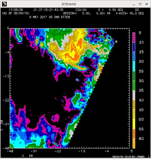
X-band attenuation: 2137 - 2150 UTC
The CSU-CHILL radar continued to execute a combination of PPI sector volume scans and two-sweep RHI's as the storm approached the radar site. An expanding area of high reflectivity and significant differential propagation phase shift developed with time at the lowest elevation angle (0.5 deg). These signatures are typical of increasing rain rates. The final image loop was made from the 0.5 deg PPI sweep data in a sequence of three volume scans (starting times of 2137, 2145, and 2150 UTC). For each volume, the first image frame shows the basic S-band reflectivity field (labeled DZ in the upper right). The second image shows the S-band reflectivity thresholded at the X-band +3 dB SNR level (DZth). The reduction in echo area brought about by this thresholding is a representation of the area where attenuation from the high rain rates has essentially extinguished the X-band return. The increasing X-band signal extinction confirms the development of high precipitation rates as the storm crossed major portions of the city of Greeley. Significant flooding of streets and businesses was reported in Greeley. Much of the CHILL radar site was also covered by standing water following the storm passage. A nearly continuous layer of small hailstones was floating on top of this rain water accumulation at the radar.
|
|
||
|