DPWX/Dual-Doppler analysis of low-level winds in a thunderstorm complex: 27 August 2014: Difference between revisions
(→References: Added reference link) |
m (Added dual doppler category link) |
||
| Line 49: | Line 49: | ||
[[Category:Thunderstorm outflow]] | [[Category:Thunderstorm outflow]] | ||
[[Category:Rain]] | [[Category:Rain]] | ||
[[Category:Dual Doppler]] | |||
Latest revision as of 13:03, 27 May 2015
Author: Patrick C. Kennedy
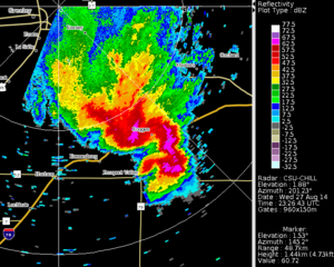
CSU-CHILL reflectivity data in a low elevation angle PPI scan through a thunderstorm complex on 27 August 2014. The horizontal wind field at the 2.4 km MSL height level in the storm, and in the ambient environment ahead of the precipitation system, has been synthesized using dual-Doppler techniques.
Overview
During the late afternoon hours of 27 August, a number of thunderstorms began to develop and organize to the east and south of the CSU-CHILL radar site near Greeley, Colorado. The CSU-CHILL radar began a shallow PPI sector scan volume at 2325:30 UTC; by fortunate coincidence, the NWS KFTG radar started a volume at 2325:48 UTC. This good volume start synchronization supported the application of dual-Doppler wind field synthesis techniques. These results are tempered by the relatively long baseline separating the two radars. (KFTG is located at azimuth 173 degrees / range 74 km with respect to CHILL). The U, V horizontal wind field components were produced using the NCAR CEDRIC program. The gridded individual radar input data required by CEDRIC was obtained using the NCAR Radx2Grid program.
Horizontal wind field at 2.4 km MSL
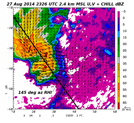
The vectors in the following plot show the dual Doppler derived U, V horizontal wind field components at the 2.4 km MSL height level (approximately 1.1 km AGL). These winds are Earth-relative (i.e., no storm motion vector has been subtracted.) Low level ouflow from the thunderstorm complex caused relatively strong, generally westerly winds to occur in the immediate vicinity of the complex. A fine line echo was located along the leading edge of this outflow. To the east of this outflow boundary in the lower reflectivity clear air boundary layer echo, a weaker, northeasterly flow regime existed.
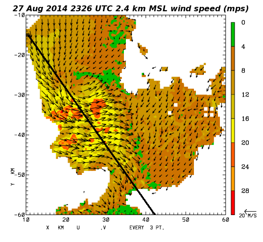
Another view of the mesoscale horizontal wind field is provided by wind speeds that are shown as a color fill in the following plot. These speeds are based on the U, V vector components shown in the preceding plot. The strongest wind speeds are found in the storm outflow region. Localized maxima with wind speeds > ~20 mps tend to occur along the leading edges of the reflectivity cores. Relatively low wind speeds were present immediately ahead of the advancing outflow boundary.
RHI data
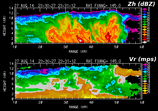
The CSU-CHILL conducted several RHI scans through the echo system starting around 2330 UTC (~6 minutes after the dual Doppler analysis time). The following plot shows the reflectivity and radial velocity data in the RHI scan done on the 145 degree azimuth. (For reference, this azimuth is marked in the 2.4 km MSL dual Doppler plots). This RHI intercepted two of the echo cores within the storm complex. The widespread nature of the surface-based cold air outflow layer beneath the echo system is apparent in the organization of the positive (away from the radar) radial velocities. This outflow probably contributed to the southeastward extension of the reflectivity contours at heights below ~2 km AGL. Evidence of storm top divergence existed near a range of 50 km and a height of ~13 km AGL.
Rainfall rates based on dual polarization data
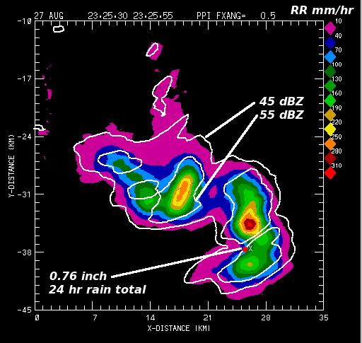
Instantaneous rain rates were calculated from the gridded 2.4 km MSL height level CSU-CHILL dual polarization data using the methods of [Cifelli et al, 2011]. The next plot shows these rain rates in a sub-region of the dual-Doppler analysis domain. Peak rain rates of several hundered mm / hr were diagnosed. Due to the storm area's fairly rapid movement towards the east-southeast, these high rain rates only occurred for brief periods of time. A member of the Community Collaborative Rain, Hail and Snow Network (CoCoRAHS) reported a 24hr rain total accumulation of 0.76 inches (19.3 mm) at the indicated location on the plot.
Summary
A mesoscale low level outflow airmass was generated by the combined effects of several thunderstorm cells within a convective complex that was observed southeast of the CSU-CHILL radar on 27 August 2014. Dual Doppler analyses using data collected by the CSU-CHILL and NWS KFTG radars allowed some aspects of the horizontal wind field at the 2.4 km MSL height level to be examined.
References
- [*Cifelli et al, 2011] A New Dual-Polarization Radar Rainfall Algorithm: Application in Colorado Precipitation Events R. Cifelli, V. Chandrasekar, S. Lim, P. C. Kennedy, Y. Wang, S. A. Rutledge, Journal of Atmospheric and Oceanic Technology, Volume 28, Issue 3 (March 2011) pp. 352-364