Polarimetric Rainfall case at DIA: 19 June 2003
CSU-CHILL Radar Rainfall Estimates at KDEN ASOS site during the 21 UTC hour on 19 June 2003
Overview
Storm event of interest was a thunderstorm passage observed at the Denver International Airport (KDEN; also informally known as "DIA") that started around 1500 MDT / 2100 UTC during the afternoon of 19 June 2003. The storm generally tracked from south to north as it slowly crossed the airport. CSU-CHILL operations were being conducted for the COMET 2003 20 hr project. Radar scanning in this project consisted mainly of relatively low angle PPI scans to support the generation of radar-estimated rainfall maps. RHI scans were interactively added through echoes of particular interest.
Chronology
Chronology based on the observer remarks in the KDEN surface weather observations (METARS):
- 2107 UTC: Peak surface wind noted (from 150 degrees at 39 knots).
- 2108: rain begins
- 2129: small hail begins (code GS; maximum hailstone diameter under 0.25 inches)
- 2206: small hail ends
ASOS rainfall summary
Between 2108 and 2145 UTC the ASOS tipping bucket rain gage reported .89 inches (22.6 mm) of rain.
General radar depictions of the storm over KDEN
Reflectivity
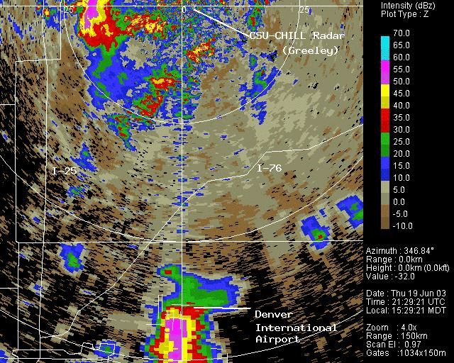
The highest reflectivity levels in the storm were over the southeastern portion of the DIA runway system at ~2128 UTC:
Reflectivity RHI
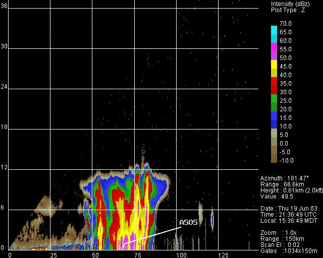
Two RHI sweeps in the vicinity of the KDEN ASOS site were done at ~ 2137 UTC. (The ASOS site is at an azimuth of 181.4 degrees and a range of 66.77 km from CHILL). Below is the reflectivity field:
Phidp RHI
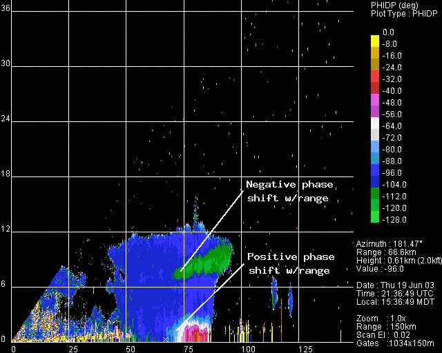
The following is the propagation phase (phidp) field. The positive (up the color scale) phase shift with range through the lower parts of the storm is due to the large numbers of oblate drops present within the rain area. (The region in the upper part of the echo where the displayed colors move down the color scale with increasing range indicates that in the mean, the particle's major axes are oriented quasi-vertically. These are probably ice particles which are being vertically aligned by the local electric field).
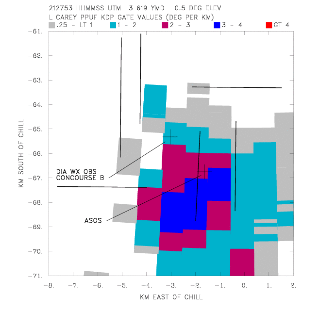
For rain rate estimation purposes, the range derivative of the propagation phase signal (Kdp; specific differential propagation (deg/km)) is required. Shown below in PPI format is the Kdp field at ~2128 UTC. As is typical of thunderstorm precipitation, large spatial variability exists. In concert with the basic reflectivity PPI display shown above, the largest Kdp values are located just south of the ASOS site. Essentially no rain is indicated over the northwestern parts of the runway complex.
Performance of various radar - rainfall rate estimators
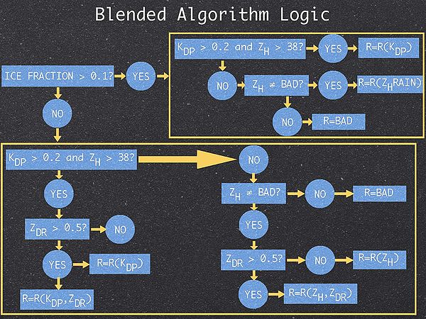
The CSU hybrid rain estimation scheme uses the polarimetric data characteristics of the precipitation to select from a number of different rainfall rate estimators. The logic used to make the estimator selection is shown in this diagram:
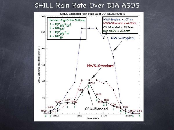
For this analysis the CSU-CHILL data were interpolated to a 1 km horizontal mesh size Cartesian grid. A Cressman weighting scheme was used with a cut off radius of .5 km. The origin of the interpolation grid was located so as to position one of the grid points at the ASOS location. The actions of the hybrid rain program during the storm passage over the KDEN ASOS grid point are summarized in the following time series plot. The entries along the time axis indicate the start time of each CSU-CHILL volume scan. The dull red decimal number associated with each volume scan time is the polarimetrically-diagnosed ice fraction in the precipitation. The green integer numbers indicate the particular rain estimator that the hybrid scheme selected to apply in that volume. (Note: In this application the leading coefficient in the R(Kdp) expression was 40.5 and the exponent was 0.85).
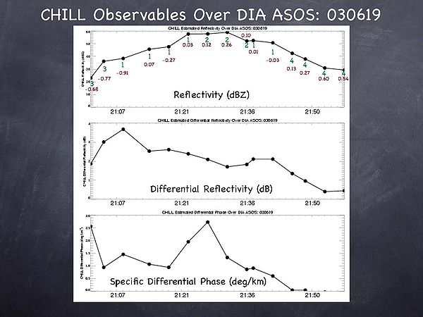
The time series of selected radar fields are shown below:
Conclusions
The total rainfall estimated by the hybrid rain algorithm agreed fairly well with the rain accumulation reported by ASOS between 2108 and 2145 UTC. In contrast, noticeable rainfall over estimates were produced by both the conventional and tropical precipitation forms of the WSR-88D estimators. These over estimates came about due to the reflectivity enhancement caused by hail component in the precipitation. Even though the polarimetrically-diagnosed ice fractions were not large during the intense phase of the storm (~15 - 25%), they still compromised the utility of reflectivity-based rain rate estimators. The large ice fractions during the last few volume scans were not considered by the algorithm since the reflectivity was below 38 dBZ and the Kdp was negligible.
To reduce the hail contamination effects, the hybrid rain scheme discarded the reflectivity data during most of the event at the ASOS site. The capability to make usable estimates of the convective rainfall rate in the presence of hail is a major benefit of polarimetric weather radar technology.
Credits
Article written by Rob Cifelli (CSU Atmospheric Science Dept.) and Pat Kennedy (CSU-CHILL Radar Facility) on 9 March 2004.
