Mesocyclone observed in the FRONT network by the NCAR S-POL and CSU-CHILL radars: 21 May 2014
Authors: P. C. Kennedy and S. Yuter

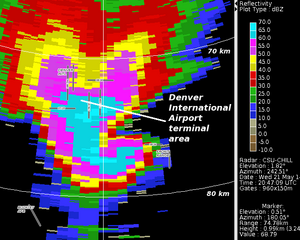
CSU-CHILL reflectivity data collected in a 0.5 degree elevation angle PPI scan through a supercell thunderstorm located just south of the Denver International Airport at 2047 UTC on 21 May 2014. On this date, Front Range Observational Network Testbed (FRONT) operations were being conducted by the NCAR S-Pol and CSU-CHILL radars in support of the North Carolina State University ROSE (Radar Observations of Storms for Education) project. Example dual-Doppler and dual polarization plots have been prepared.
Introduction
During the afternoon hours of 21 May 2014, the NCAR S-Pol and CSU-CHILL radars were collecting data for Prof. Sandra Yuter's ROSE (Radar Observations of Storms for Education) NSF-funded project. These two NSF research radars anchor the Front Range Observational Network Testbed (FRONT). To support dual-Doppler analyses, the ROSE project data collection procedures set the antenna control programs at both radars to synchronize the starting times of their scan sequences. A supercell thunderstorm that developed over the northeastern Denver area and then passed just south of Denver Internatiional Airport was observed in the course of the synchronized ROSE project scans. This article presents basic "snapshot" data plots obtained from a single synchronized volume scan collected on 21 May 2014 by the FRONT research radars during the ROSE project.
Dual Doppler-based horizontal wind fields at 2.6 km MSL
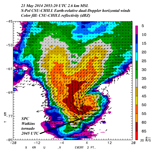
During the volume scan that started at 2053:20 UTC, the supercell's hook echo had moved into the southern extremity of the east lobe of the S-Pol - CSU-CHILL radar pair. Within this lobe, the radial velocity measurements obtained by the two radars were from sufficiently different directions to support the accurate synthesis of the horizontal wind field. The following plot shows the resultant dual Doppler wind field synthesis obtained at a height of 2.6 km MSL (approximately 1 km AGL). To support this analysis, the input polar coordinate data from each radar was interpolated to a common Cartesian grid using the NCAR SPRINT program. The horizontal grid mesh is 0.5 km and the grid origin is at CSU-CHILL. The NCAR CEDRIC program synthesized the horizontal wind field from the two gridded radial velocity input fields. The mesocyclone circulation pattern is evident centered near the tip of the hook echo. The Storm Prediction Center (SPC) files contain several tornado reports in association with this storm SPC reports. The plot has been annotated with the location of the SPC report of a tornado at Watkins, CO at 2045 UTC (~8 minutes before the analysis time).

Selected S-Pol dual polarization data fields
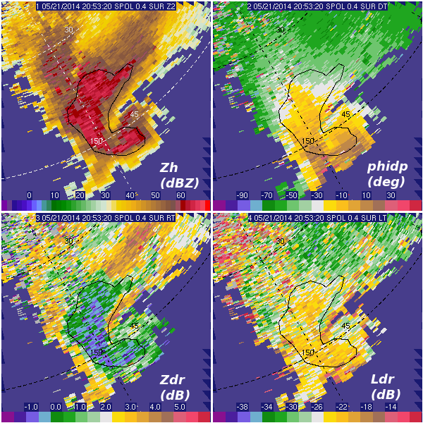
At 2053:20 UTC, the storm was at closer range to S-Pol than to CSU-CHILL. For this reason, data from an S-Pol 0.4° elevation PPI sweep was selected to show the dual-polarization characteristics of the storm's precipitation at near-surface heights. The data shown in the following SOLO plot was subjectively thresholded / edited to remove ground clutter and non-precipitation clear air echo. An irregular boundary was drawn in the reflectivity (upper left) to identify the combined echo core and hook appendage regions. The differential propagation phase () field shown in the upper right indicates that phase shifts due to the presence of heavy rain (i.e. containing large oblate drops) were accumulating in both the echo core and hook areas. The text of the NWS warnings issued for this storm consistently noted that rain wrapping around the mesocyclone would make visual tornado detection difficult. The ~0 dB differential reflectivities (lower left), and enhanced linear depolarization levels (; lower right) indicate that hailstones were also a major component of the precipitation within the irregular boundary. Surface observations confirmed the presence of heavy rain and hail. At 2053 UTC the METAR observation taken at Denver International Airport ((KDEN); located ~13 km northwest of the tip of the hook) included a visibility of 1 statute mile due to present weather conditions of a thunderstorm with heavy rain and small hail (+TSRAGS).

Summary
The ROSE project is the first NSF-sponsored field project supported by the FRONT network. The life cycle of a supercell thunderstorm observed by the FRONT research radars on 21 May 2014 should provide a useful addition to the library of educational cases that the ROSE project is designed to assemble.


