Hydrometeor classification example
Various methods have been developed to classify weather radar echo types by objectively combining the basic data collected by polarimetric radars (i.e., , , /, etc.). One level of classification involves differentiating between meteorological and non-meteorological echoes (ground clutter / anomalous propagation, insects, chaff, etc.) Once the meteorological echoes have been identified, additional classification procedures can be applied to identify the primary hydrometeor type (rain, snow, hail, etc.)
Membership Functions
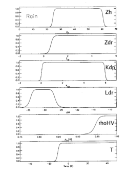
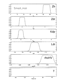
The hydrometeor identification example shown here is based on the application of membership functions that define the range of polarimetric radar data values that are associated with a prescribed set of hydrometeor classes. The membership functions for the rain and small hail classifications are shown below
 |
 |
For each variable, the membership function maximizes over the range of data values that are best correlated with a given hydrometeor type. For example, the rain classification membership function values increase towards 1 as reflectivity exceeds ~24 dBZ, and become increasingly positive, etc. In contrast, the small hail membership functions maximize for the higher reflectivity / near 0 dB / negligible ’s that are typically associated with the signal returns from tumbling hailstones. It is apparent that that some overlap exists among the membership functions (i.e., a reflectivity of 50 dBZ could be associated with either rain or small hail). The application of these tapering, overlapping membership functions is the basis of fuzzy logic echo classification procedures. (This is in contrast to hard, single-value decision thresholds such as “hail is possible only when the reflectivity is at least 53 dBZ”).
In the fuzzy logic hydrometeor classification method demonstrated here, the basic polarimetric radar quantities are used to evaluate the membership functions for all of the ~11 prescribed hydrometeor types. An additional weighting factor is applied to account for the applicability of a particular radar variable to the identification a given hydrometeor classification. For example, in summing up the membership function values for moderate and heavy rain, the weight applied to the LDR membership function is reduced since little LDR variation is expected between these two rain categories. At each range gate, the weighted membership functions are summed for all of the possible hydrometeor types; the hydrometeor type that develops the largest summed membership function value is selected as being the most probable hydrometeor type.
It should be noted that an additional environmental temperature constraint is also applied to some of the hydrometeor classifications. The temperature function shown at the bottom of the rain membership function series is used to suppress the assignment of the rain classification when temperatures are well below freezing.
Example Cases
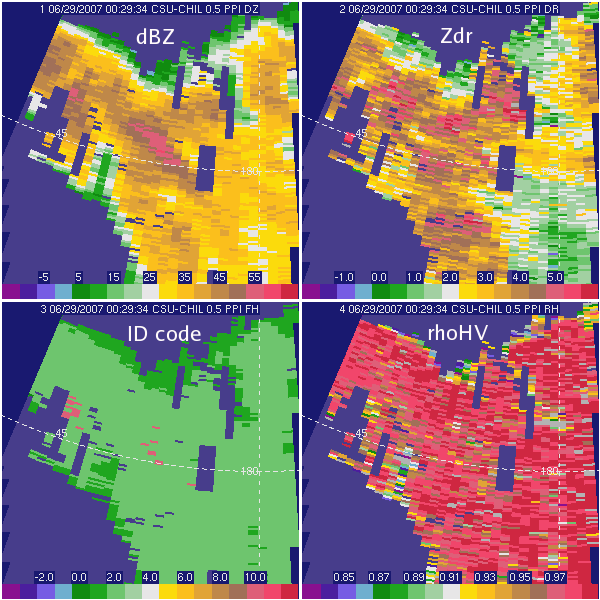
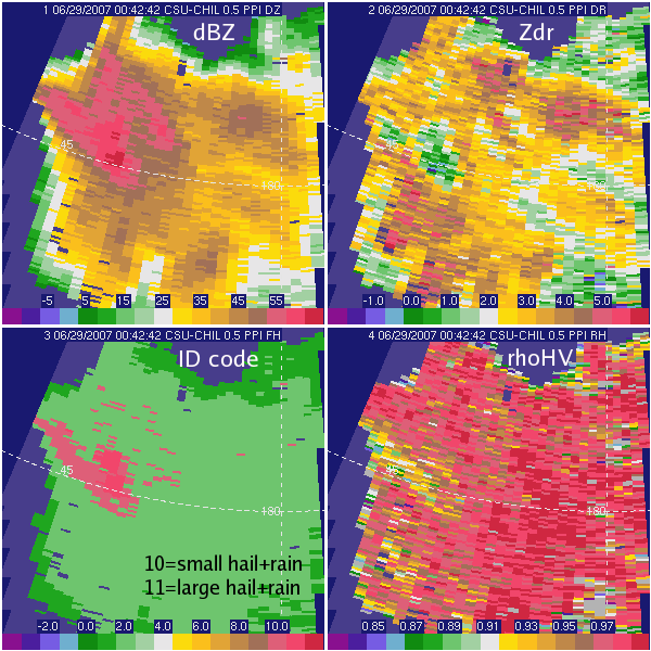
The following two PPI plots show CSU-CHILL data collected in two 0.5° sweeps through an evolving severe thunderstorm; the observations are seperated in time by ~13 minutes. The hydrometeor classifications are color coded in the lower left panel. Hydrometeor classification codes of 10 and 11 are associated with mixtures of rain and hail and appear as shades of red on this color table. (Green shades are rain). The hydrometeor classification algorithm identifies the onset of hail between the two PPI sweep times. (The associated dBZ, , and values are shown in the three neighboring panels). A severe weather spotter report verified the existence of heavy rain and hail of up to one inch diameter in the immediate vicinity of the radar-implied large hail and rain classification.

Additional Links
- Fuzzy Logic on Wikipedia
- Hydrometeor types on Wikipedia


