High time resolution RHI's through a snow band: 4 March 2013
Author: P. C. Kennedy

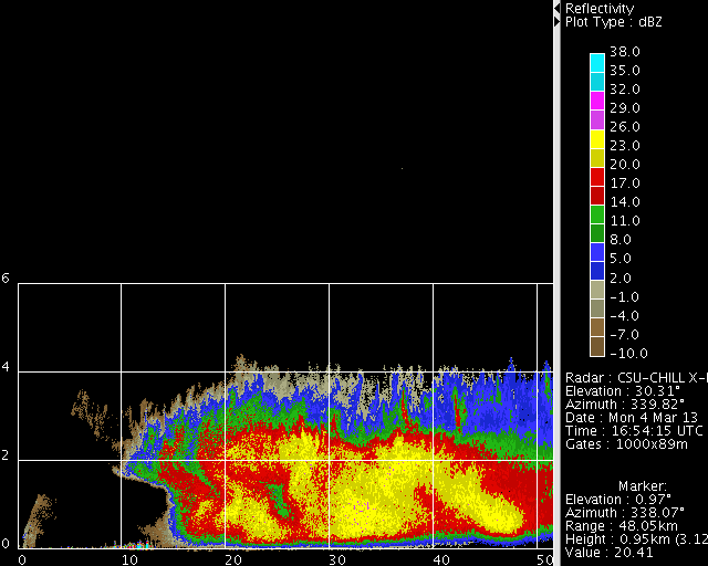
X-Band / 9 GHz reflectivity data collected by the CSU-CHILL radar in a 2.8 deg elevation angle PPI sweep. Shortly after the PPI volume was completed, a series of RHI scans that repeated at ~ 1 minute intervals were done through the approaching snow band. Time lapse loops of these RHI observations have been prepared.
Introduction
During the mid-morning hours of 4 March 2013, the functioning of several elements of the signal processing software used in the CSU-CHILL X-Band channel was being examined. To provide a steady stream of input data, the antenna controller was adjusted to repeat two sweep RHI volumes (upward sweep on azimuth 338 deg and downwards on 340 degrees). These azimuths intersected a band of light to moderate snow that was advancing towards the radar from the north. This scan pattern caused each RHI sweep to be repeated at intervals of ~1 minute. Animations of the resultant high time resolution observations reveal several organization features of the snow band.
dBZ loop
The cellular appearance of the reflectivity structures in the upper ~1/3 of the echo system suggested that convection was occurring on horizontal scales of a few km (McFarquhar et. al., 2011). In the lower levels of the echo system, the reflectivity patterns were suggestive of "streamers" of aggregated snow particles. The orientations of these precipitation trails became curved as they fell through the vertical variations in the horizontal wind field. Towards the later time in the loop, the slope of the > 20 dBZ (yellow) reflectivity streamers with respect to height reversed. (The missing pixels that sporadically appear are due to the clutter filter that was being used during these test operations.)
|
|
||
|
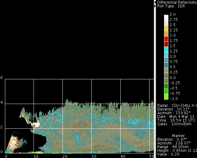
Differential Reflectivity (Zdr) loop
Several regions of enhanced positive Zdr were evident during the duration of the loop. The most positive (> 3 dB) Zdr values occurred in the elevated layer that projected towards the radar from the leading edge of the snow band. The reflectivity values in this region were generally below 10 dBZ. The implied low particle concentrations reduced the frequency of ice crystal collisions and aggregation. The planar shapes and quasi-horizontal orientation of these pristine crystals lead to the distinctly positive Zdr values. At longer ranges, where the echo reached to the surface, Zdr's tended to reach the +1 to +2 dB range in the vicinity of the 2.5 - 3 km AGL height level (~ -12 to -14 deg C on the 12 UTC DNR sounding). Vigorous crystal growth at these temperatures in the saturated environment of the snow band probably caused this Zdr enhancement. Finally, there was a tendency for somewhat positive Zdr values to descend toward the surface towards the outer margins of some of the precipitation trails.
|
|
||
|
Convective Structures in the Leading Edge of the Echo at 1701 UTC
A more detailed view of some of the features of the leading edge of the echo system at 1701 UTC are shown in the following RHI plot. The reflectivity data indicates that the elevated cellular elements tended to increase in vertical extent and intensity with distance into the snow band. (i.e between ranges of ~10 to 15 km). The implied convective vertical motions appeared to disrupt the positive Zdr regime that was typical of the more quiescent, near-range portion of the echo. It is speculated that presence of more heavily rimed aggregates in the convective updrafts caused the Zdr values to decrease to the ~0 dB range typical of quasi-spherical / unaligned particles. The radial velocity pattern displayed slight fluctuations in the vicinity of the upper level convective elements. (Note: To better show the subtle velocity details, the limits of the color scale are only +/- 4.5 mps). A more laminar flow pattern prevailed in the lower half of the snow band.

Summary
Observations obtained at high resolution in both time and space while the CSU-CHILL radar was operating in X-band only configuration revealed several aspects of the precipitation processes occurring within a snow band.
Reference:
High Resolution Measurements of Cyclone Structure: the Profiling of Winter Storms Project (PLOWS)
Grand Ballroom (William Penn Hotel)
Greg M. McFarquhar, University of Illinois, Urbana, IL; and R. M. Rauber, B. F. Jewett, K. R. Knupp, P. S. Market, D. Leon, D. M. Plummer, A. A. Rosenow, M. K. Peterson, and M. Pitcel
Paper 208 at 35th AMS Conference on Radar Meteorology, Pittsburgh, 26-30 Sept. 2011