Dual polarization signatures of melting hydrometeors: 23 August 2013
Author: P. C. Kennedy
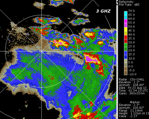
Low elevation angle CSU-CHILL PPI scan containing both stratiform and convective rain near 02 UTC on 23 August 2013. An RHI scan taken ~2 minutes later showed markedly different dual-polarization indications of hydrometeor melting in these two rain regimes.
Overview
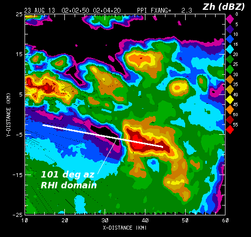
Around 2005 MDT on 22 August 2013 (0205 UTC on 23 August), the thunderstorm activity that had developed during the afternoon hours was beginning to dissipate. In areas where the convective vertical motions were no longer active, the precipitation became more stratiform in character. An RHI scan done by the CSU-CHILL radar on an azimuth of 101° intercepted stratiform rain at closer ranges, and a thunderstorm convective core at more distant ranges. Dual polarization indications of melting hydrometeors occurred at differing height levels in these two echo regimes. The following plot of the reflectivity data observed in the 2.3° PPI shows the general situation. The solid white line shows the location of the RHI scan data that was collected ~2 minutes after the PPI data. (Note: The CSU-CHILL X-band system was out of service on this date. All of the data is from the 11 cm wavelength / 3 GHZ channel.)
RHI data
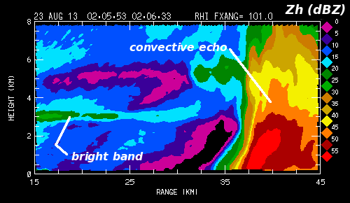
The first plot shows the vertical structure of the reflectivity field. A horizontally-oriented brightband echo was present in the nearer-range / light stratiform rain area. The water coating that develops as frozen hydrometeors descend through the 0°C level is a major factor in generating the local reflectivity enhancement. When the snow particles completely melt, they collapse into raindrops with smaller diameters and higher terminal fall speeds than their "parent" melting hydrometeors. This shift to smaller particle diameters and lower volumetric concentrations reduces the reflectivity at heights below the bright band. At ranges beyond ~35 km, the strong updrafts in a thunderstorm lead to the growth of many large-diameter hydrometeors, yielding significantly higher reflectivity levels.
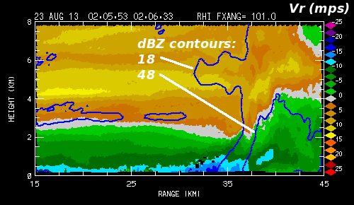
The next plot shows the corresponding radial velocity field. The 18 and 48 dBZ reflectivity contours are overlaid to help identify the bright band and convective core regions. Convergence and a probable updraft are implied near X=37, Z=4 km. Outflow from the convective cell's downdraft is responsible for the enhanced inbound (negative in sign) velocities near the surface.
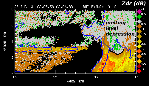
The next plot shows the corresponding differential reflectivity () field. In the bright band, the most positive values are restricted to a narrow height layer where the developing melt water content in the descending ice particles is significant. This water component enhances the dielectric constant of the particles, making the horizontally aligned shape that develops during a portion of the melting process more apparent to the radar; thus increasing . [Herzegh and Jameson 1992:1365-1374] When the particles fully melt, the oblateness of the resultant drops is reduced relative to that of the partially-melted state, producing less positive . Within the convective echo core, the patterns have a much less layered appearance. Positive values extend to ~5 km AGL in general association with the updraft near X=37 km. Oblate raindrops that are lofted above the 0°C level by updrafts typically contribute to such positive "columns". At greater ranges (~X=40 km) in the main precipitation shaft, the development of positive values is delayed to heights of ~3 km AGL (i.e., several hundred meters below the brightband level). This melting level depression is due to the longer time required for melting to proceed in the more massive ice particles (graupel and small hailstones) in the convective precipitation core. The higher terminal fall speeds of these particles, aided by downdrafts in the echo core, also cause enhancements due to melting to appear at lower heights.
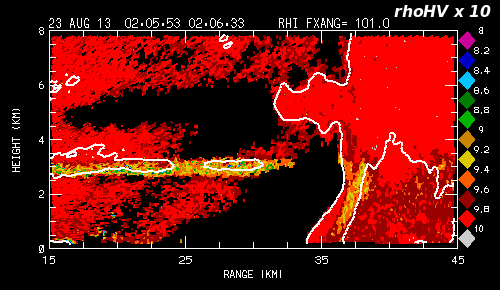
The co-polar correlation coefficient between the horizontal (H) and vertical (V) signal returns (; multiplied by 10 in this example) is shown in the next plot. is decreased when the radar pulse volume contains a diverse variety of hydrometeor shapes, orientations, and thermodynamic phases. Melting regions, where quasi-spherical, fully melted drops coexist with large, irregular, partially melted ice particles are characterized by locally reduced [Balakrishnan and Zrnic 1990:1525-1540]. Correlation coefficient reductions to ~0.9 and below occur in the mixed phase region of the bright band. A second, vertically-oriented correlation minimum is also found in the reflectivity maximum along the near edge of the convective precipitation area (X=35 to 37 km) where raindrops are mixed with melting graupel.
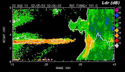
The final dual polarization variable presented is linear depolarization ratio (). is the ratio of the cross-polar received signal level to the co-polar received signal level. The cross-polar signal is increased when the major axis of non-spherical hydrometeors is oriented out of the polarization plane of the incident radar waves. The orientation angle fluctuations observed for larger diameter frozen hydrometeors is generally greater than the orientation variations of raindrops. [List and Schemenauer 1971:110-115] When these "wobbling" ice particles contain a substantial liquid water component (i.e, during melting or the accretion of liquid drops, etc.), they become particularly effective in increasing the cross-polar return signal component. As shown in the following plot, levels reach peak levels of ~ -15 dB in the areas where melting is occurring in the bright band and in the low level reflectivity maximum at the near edge of the convective precipitation shaft. Outside of these melting regions, where the particles are either solidly frozen ice particles or else liquid drops, the levels are generally in the -20 to -30 dB range. (i.e., the cross-polar signal level is only .01 to .001 as large as the co-polar returned signal level.)
Summary
The melting region in precipitation systems is characterized by diverse populations of particles in a range of thermodynamic states (small, fully melted drops, larger, irregularly-shaped partially melted aggregates, etc.) In terms of polarimetric measurements, these particle populations act to locally
- Increase
- Reduce
- Enhance .
Dual polarization radar observations are thus quite useful for identifying regions where hydrometeor melting is occurring within precipitation systems.
References
- [*Herzegh and Jameson 1992] Herzegh, Paul H., Arthur R. Jameson, 1992: Observing Precipitation through Dual-Polarization Radar Measurements. Bull. Amer. Meteor. Soc., 73, 1365–1374.
- [*Balakrishnan and Zrnic 1990] Balakrishnan, N., D. S. Zrnic, 1990: Use of Polarization to Characterize Precipitation and Discriminate Large Hail. J. Atmos. Sci., 47, 1525–1540.
- [*List and Schemenauer 1971] List, Roland, Robert S. Schemenauer, 1971: Free-Fall Behavior of Planar Snow Crystals, Conical Graupel and Small Hail. J. Atmos. Sci., 28, 110–115.


