Dual polarization fields in the 14 August 2008 hailstorm
Overview
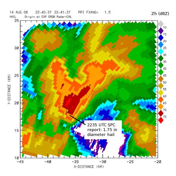
A severe thunderstorm that produced large, damaging hail affected areas to the north of Fort Collins Colorado during the afternoon hours of 14 August 2008. The CSU-CHILL radar observed this storm while transmitting in alternating H, V polarization mode and making a continuous series of low elevation angle 360 degree PPI scans in support of a rain mapping project. The following plots were extracted from a single PPI sweep that was recorded while the storm was essentially at its peak intensity.
Horizontal Reflectivity ()
The 1.5 degree elevation angle PPI sweep contained echo core reflectivity values in excess of 70 dBZ at 2240 UTC. According to a severe weather spotter report logged at 2235 UTC, 1.75 inch diameter hail was observed in this high reflectivity area. The storm spotter location is marked with an “H” in the plot.

Differential Reflectivity ()
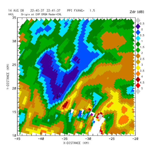
Since hailstones are essentially immune to physical deformation by aerodynamic forces, and since they tend to gyrate through relatively random orientations as they fall, they give approximately equal co-polar return signal levels when illuminated by either horizontally or vertically polarized radar pulses. Differential reflectivity () is defined by , so the presence of hailstones is typically associated with values around 0 dB. In contrast, falling raindrops tend to assume flattened shapes that make become greater than , yielding positive values. (The "" notation sequence indicates the received polarization (first h) and the transmitted polarization (second h)). The existence of an ~0 dB minima in a high reflectivity region distinguishes the hail core from the surrounding positive rain area.
Linear Depolarization Ratio ()
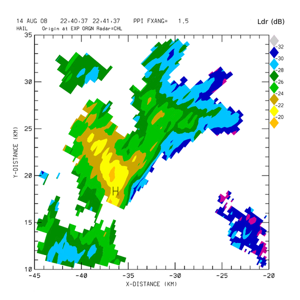
When hailstones are not perfectly spherical (which is generally the case), their tumbling motions cause some of the backscattered radiation to contain a small signal component that is polarized orthogonally (cross polar) to the incident radar pulse. (i.e., when a nonspherical, tumbling hailstone is illuminated by a horizontally-polarized radar pulse, the signal scattered back to the radar will also contain a small vertically polarized fraction.). Linear depolarization ratio is a measure of the ratio of the cross polar and co-polar received signal levels. In the following plot, values tend to maximize in the hail area. (The negative values arise since the cross polar signal level is smaller than the co-polar level, making the argument of the log term less than one
.
Hail Differential Reflectivity ()
The parameter was devised by Aydin et al. (JAM, 1986 p1475-1484) to exploit the differing characteristics of raindrops and hailstones. These authors defined an algebraic expression for based upon the combined observations of and in convective precipitation at above 0°C temperatures. When the computed value becomes positive, the existence of hail becomes more likely. Depue et. al. (JAMC 2007 p1290-1301) examined the relationship between magnitudes and ground observations of hailstone diameters. An threshold value of +21 dB was found to be correlated with ground truth observations of hailstone diameters of 0.75 inches or greater (The NWS definition of large hail.) The final plot shown below is an interactive map depiction of the +21 dB contour as calculated from the PPI sweep data shown in the earlier plots. The SPC hail report was located within the southern portion of the +21 dB contour.
<gmap lat="40.679180" long="-105.022275" zoom="12" width="600" height="600" showscale="on"> points: 40.61|-105.07|1.75 inch diameter hail reported at 2235 UTC.
40.44625|-104.63708|CSU-CHILL

kml: http://www.chill.colostate.edu/kml/fa_feb09/hdr_contour.kml%7CHDR Contour </gmap>
References
- Aydin, K., T. Seliga, and V. Balaji, 1986: Remote Sensing of Hail with a Dual Linear Polarization Radar. J. Appl. Meteor., 25, 1475–1484.
- Depue, T.K., P.C. Kennedy, and S.A. Rutledge, 2007: Performance of the Hail Differential Reflectivity () Polarimetric Radar Hail Indicator. J. Appl. Meteor. Climatol., 46, 1290–1301.


