Dual-Doppler mesocyclone observations: 20 July 2013
Authors: P. C. Kennedy and F. Junyent

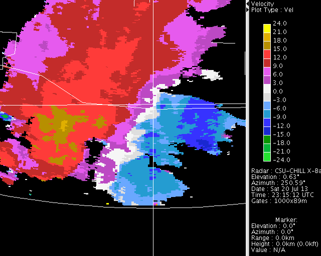
Mesocyclone radial velocity pattern (circled) at a range of ~15 km from the NWS KFTG radar on 20 July 2013. The narrow (0.3 deg) beamwidth of the CSU-CHILL X-band (9 GHZ) channel allowed the collection of high resolution data from this same circulation despite its being at a range of ~80 km. Various data plots, including a dual-Doppler horizontal wind field synthesis, have been prepared.
Overview
During the late afternoon hours of 20 July 2013, the CSU-CHILL radar was conducting low-elevation angle PPI sector scans in support of a rainfall mapping project. Due to a technical fault in the transmitter cooling system, the S-band (3 GHZ) portion of the radar was not operable. Data was collected with the CHILL's X-band (9 GHZ) channel. Since the large (9.5 m diameter) S-band antenna is shared by the X-band equipment, a very narrow (0.3 deg 3 dB beamwidth) beam pattern is obtained at X-band. This narrow beam width allowed the collection of high spatial resolution observations of a mesocyclone that developed at a range of ~ 80 km.
The mesocyclone
The following plot of X-band radial velocities shows the location of the mesocyclone during its well defined stage at 2328 UTC. At this time, the circulation was ~ 8 km east of the center of the city of Aurora, Colorado. (Negative velocities indicate motion towards the radar; positive is away). Peak radial velocities were modest. No velocities were beyond the ~ +/- 24 mps Nyquist range provided by the X-band's dual PRF pulsing scheme.

Radial velocity loop
The following loop contains a sequence of ten 0.5 deg elevation PPI sweeps taken at 1.5 minute time intervals. The narrowing of the white near zero radial velocity band is indicative of increasing low-level convergence. Several cyclonic circulation couplets / kinks can be seen along the zero radial velocity band. The primary circulation itself moves southward along a cyclonically-curved path.
|
|
||
|
Dual-Doppler analysis
The CSU-CHILL and NWS KFTG radars started volume scans within ~1 minute of each other around 2328 UTC. The radial velocities observed from the two different viewing directions of these radars were used to generate a dual-Doppler synthesis of the horizontal wind field. The data from each radar was interpolated to a common 0.2 km mesh Cartesian grid using the NCAR SPRINT software. The wind field was synthesized from the gridded input fields using the NCAR CEDRIC program. The following plot shows the Earth-relative horizontal wind field at the 2.8 km MSL level (~ 1.1 km AGL). The mesocyclone circulation was evident centered near X=-4, Y= -82 km from the grid origin at CHILL. To avoid attenuation uncertainties, the color fill shows the KFTG reflectivity values. The 50 dBZ contour contains a hook shape in association with the mesocyclone. The NWS issued a tornado warning at the time of this analysis (2328 UTC) based on the circulation patterns seen in the KFTG radial velocity data. (Storm Prediction Center records do not contain any confirmation of a tornado associated with this storm.)

RHI data
The time rate of change of the phase of the received signal is the basis of the radial velocity data presented above. Dual-polarization Doppler radars can also measure the phase difference between the horizontally (H) and vertically-polarized (V) received signals (differential propagation phase; ()). Since phase measurements do not require attenuation corrections, the CSU-CHILL X-band system collects high resolution observations of as well as radial velocity in thunderstorms, provided that attenuation has not fully extinguished the signal. It should also be noted that magnitude is proportional to the radar frequency. X-band shifts will be ~3 times larger than those observed at S-band.

Example X-band data can be found in the brief, two sweep RHI scan was conducted through the storm on an azimuth of 179 degrees at 2333 UTC. Beam path segments where the H received phase is increasingly lagging the V phase are indicated by movement down the color scale (blue to yellow) with increasing range. Phase shift trends in this down-color scale sense occur when the forward scattering from significant concentrations of oblate hydrometeors retards the propagation of the H waves relative to the V waves. Conversely, beam paths where hydrometeors have their major axis oriented towards the vertical will cause the V retardation to exceed the H retardation. In such areas, the values will move up the color scale with increasing range. Examples of both of these trends are seen in the color fill patterns shown in the next two plots. In the first panel, the overlaid solid contours are selected attenuation-corrected X-band reflectivity levels. The reflectivity column associated with the storm core was centered near 80 km range.

In the final plot, the contour lines are the range derivative of (specific differential propagation phase (). Regions with large magnitudes are areas where non-spherical hydrometeors with preferred orientations exist in sufficient concentrations to alter over relatively short beam path range intervals. Near the surface, the high concentration of oblate raindrops produces the positive depicted by the red contours. Higher up, near the 12 km AGL level, the reversed color progression and negative contour region implies that the major axes of the hydrometeors have become oriented towards the vertical. In the upper portions of thunderstorms, this vertical orientation pattern is due to local electric fields that are strong enough to align planar ice crystals. This vertical ice crystal alignment fades when lightning discharges relax the electric field and the crystal orientation returns to the aerodynamically-favored horizontal attitude (Caylor and Chandrasekar, IEEE Transactions on Geoscience and Remote Sensing, 1996 p 847-858.)


Summary
The narrow (0.3 deg) main beamwidth achieved by the CSU-CHILL X-band system allowed high resolution observations to be made in a mesocyclone-bearing storm at a range of ~80 km.