DPWX/Onset of dual polarization hail indications: 30 April 2015
Author: Patrick C. Kennedy

CSU-CHILL low elevation angle PPI data collected in a hailstorm on 30 April 2015. The shaded overlay shows the region where the co-existence of high Zh and ~0 dB Zdr implies a significant probability of hail. Time lapse loops of radar data that show the initial development of this hail area have been prepared.
Overview
During the late afternoon hours of 30 April 2015, the CSU-CHILL radar was conducting test operations that included continuous 360 degree surveillance scans at a fixed elevation angle of 1.5 degrees with a scan rate of 4 deg per second. This scan regime produced new data files at ~1.5 minute intervals. (Each sweep is slightly more than a full revolution to ensure complete azimuthal coverage). While these scans were in progress, the appearance of dual-polarization indications of hail in a developing thunderstorm was recorded. The Denver / Boulder NWS forecast office issued a severe thunderstorm warning for this storm at 2303 UTC / 1703 MDT. This warning included the expectation of hail up to one inch in diameter and surface wind gusts to 60 mph. Due to the extremely low population density in the area traversed by this storm, no ground truth reports of this storm's actual hail production are available.

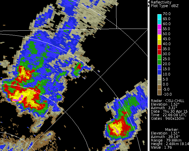
Reflectivity loop
The following loop shows the CSU-CHILL reflectivity data for the 2244 - 2315 UTC period. The hail-bearing reflectivity core in the eastern portion of the echo system appeared and quickly reached an intensity of ~60 dBZ within a 10 minute time period as hydrometeors that had developed aloft descended into the 1.5 degree elevation angle scan plane.
|
|
||
|
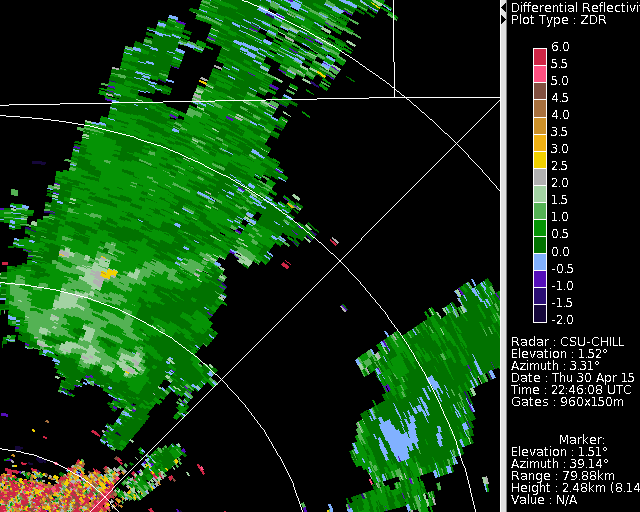
Differential reflectivity loop
The next loop shows the differential reflectivity () data from the sweeps that were used in the preceeding reflectivity loop. The red circle highlights the echo core region where is reduced to ~ 0 dB. is defined as 10 log10 (Zh / Zv) where Zh and Zv are the reflectivities observed at horizontal and vertical polarizations respectively. The approximately spherical hailstone shapes in combination with their quasi-randome tumbling motions tends to equalize Zh and Zv; a Zh / Zv ratio of 1 results in a value of 0 dB. In contrast, the net forces acting on falling raindrops produce flattened drop shapes that preferentially increase Zh relative to Zv. Thus, precipition areas that are primarily composed of raindrops are characterized by positive values (Wakimoto and Bringi, MWR 1989 p. 1521-1539.) In the image loop, levels decrease from ~ +1.5 dB to ~ 0 dB as the hailstones became an increasingly significant precipitation component in the echo core.

|
|
||
|
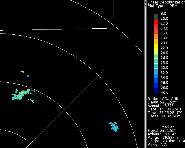
Linear depolarization ratio loop
Linear depolarization ratio () is based on the ratio of the cross-polarized received signal level to the co-polar received signal level. In the returns received from hydrometeors, the cross-polar signal is generally two to three orders of magnitude less than the co-polar signal (-20 to -30 dB on a log scale; Herzegh and Jameson, BAMS 1992, p. 1365-1374). The highest levels returned by meteorological echoes are associated with wet (large refractive index), non-spherical ice particles with major axis orientation angles reaching ~45 degrees with respect to the horizontal. The gyrating motions that are typical of freely-falling hailstones, in combination with the wet outer surface that often develops as the stones fall through warmer, near-surface height levels often causes enhancement in areas of hail. In the following loop, levels exceed -24 dB (yellow shades) in the hail area. (To reduce the effects of noise on the weak cross-polar signal, the data in the loop images is not shown when the co-polar reflectivity is less than 45 dBZ).

|
|
||
|